En Route to the Land of Gold: The Cherokee Trail in Wyoming
Western Archaeological Services
The Cherokee Trail is one of three major east-to-west oriented nineteenth century transcontinental wagon roads to cross Wyoming along with the Oregon/California, Mormon, Pony Express (Oregon Trail), and the Overland Trail. As the name implies, the Cherokee Trail was developed in part by Cherokee Indians. It began in the Cherokee Nation in what is now Oklahoma as a route leading to the California gold fields during the 1849 Gold Rush. The Oregon Trail and the Overland Trail served as the routes west for people of the American Midwest and East. The Cherokee Trail served as the route west for people from southern states including southern Missouri, Tennessee, Arkansas, Louisiana, and Texas.
Route of the trail

Tahlequah, the capitol of the Cherokee Nation, located within the Indian Territory, was the take-off point for the Cherokee Trail (Figure 1). The Indian Territory had been formed in the 1830s when the Cherokee, Choctaw, Chickasaw, Muscogee, and Seminoles were forcibly removed from their homes in Georgia, Florida, Tennessee, Alabama, and Mississippi and moved west on the Trail of Tears. The tribes gained a measure of prosperity during the 1840s, but the lure of gold in California affected the Indian Territory as much as it did the rest of the country.
Emigrants traveled north from Tahlequah into Kansas where they intersected the Santa Fe Trail, which by the 1850s was a well-established freight road connecting American states with Taos and Santa Fe, New Mexico. The Cherokee followed the Santa Fe Trail along the Arkansas River through Kansas and southern Colorado until they reached modern Pueblo, Colorado.
The Cherokee Trail then turned north and continued along the Colorado Front Range. This was also an established route, known as the Trappers Trail, which connected Taos and Santa Fe with fur trade posts on the South Platte River in Colorado and at Fort Laramie on the North Platte in what’s now Wyoming.
The Cherokee Trail followed this route north to the vicinity of modern Denver. North of Denver, the trail briefly divided into two routes. One followed the South Platte River to the mouth of the Cache la Poudre River which it followed north. The second route ran due north along the base of the Front Range. The variants converged near modern LaPorte, Colorado and continued north into present Wyoming. Here, the Cherokee Trail spilt into two distinct variants, the 1849 Evans Route and the 1850 Southern Route (Figure 2). There were also several pack trails which were used occasionally but left little or no physical trace making them almost impossible to relocate.
, Oregon (in red) and Overland (in blue) trails. The Overland Trail incorporated the earlier Cherokee Trail Evans Route in northeastern Colorado, southeastern Wyoming, and along Bitter Creek in southwestern Wyoming. Western Archaeological Services.")
Evans Route, 1849
The earliest Cherokee Trail route across Wyoming was the 1849 Evans Route. Parts of it were initially explored by John C. Fremont in 1843. Fremont explored southeastern Wyoming including the south side of Elk Mountain and a crossing of the North Platte River between modern Saratoga and Walcott. Fremont could not find a passable route west to the Continental Divide so he turned north towards the Oregon Trail on the Sweetwater River. He eventually intersected the Oregon Trail between Independence Rock and Devil’s Gate and followed it west to South Pass.
In 1849, Cherokee Indians and whites led by Lewis Evans left the Indian Territory for California. Evans may have had a copy of Fremont’s report and attempted to retrace Fremont’s route. After crossing the North Platte River, Evans also turned north toward the Oregon Trail. However, upon reaching the vicinity of modern Rawlins, Wyoming, they gave up and turned west toward the Green River. The Red Desert in mid-summer had very little standing water. Evans’ party survived on water found in playa lake beds in the Wamsutter area (Figure 3). They reached Bitter Creek near Point of Rocks and followed it west to modern Rock Springs (Figure 4). Instead of continuing down Bitter Creek to the Green River, Evans turned north and rounded the north end of White Mountain. They then turned west, crossing the Green River near the modern Sisecam Trona Mine before reaching the Oregon Trail northeast of present Granger, Wyoming.

.")
Marcy’s Variant, 1858
A secondary variant of the 1849 Evans Route paralleled the original trail across the Red Desert (Figure 5). This route was pioneered by U.S. Army Capt. Randolph Marcy in 1858. Marcy was bringing relief supplies to Fort Bridger from New Mexico following the U.S. Army take-over of the post in late 1857. Marcy followed the 1849 Cherokee Trail through eastern Colorado and southeastern Wyoming. Probably due to the lack of water along the 1849 Evans Route, Marcy developed a new route across the Red Desert south of the Evans Route. Marcy’s route ran along the base of Delaney Rim from Wamsutter past what are now the hamlets of Red Desert, Tipton and Table Rock before intersecting the Overland Trail along Bitter Creek near Big Pond.
In 1858, the U.S. Army decided to create a new military road from Fort Riley, Kansas to Fort Bridger. The Army debated between the Evans Cherokee Trail and the Bridger Pass-Bitter Creek route pioneered by Capt. Howard Stansbury in 1850 and developed by Lieutenant Francis Bryan between 1856 and 1858.
Thanks in part to Jim Bridger’s endorsement, the Stansbury-Bryan route was chosen and became the basis of the Overland Trail. Several sections of the Evans Route including the trail in eastern Colorado, the trail between present-day Tie Siding and Elk Mountain, and the trail along Bitter Creek between Point of Rocks and Rock Springs were incorporated into the Overland Trail. The remainder of the Evans and Marcy Routes in the Red Desert saw no further development and only modest amounts of traffic during the rest of the 1850s.

Southern Route, 1850
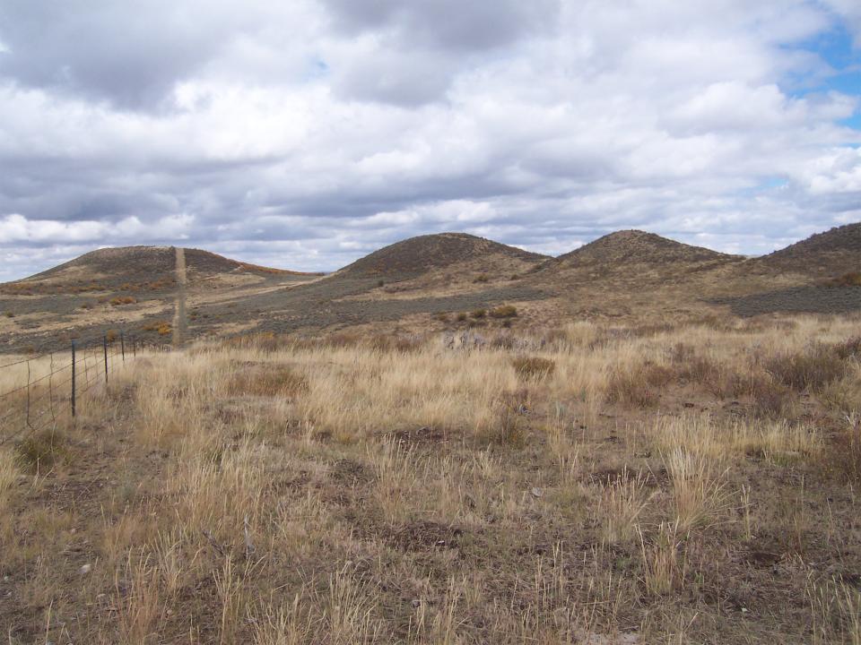
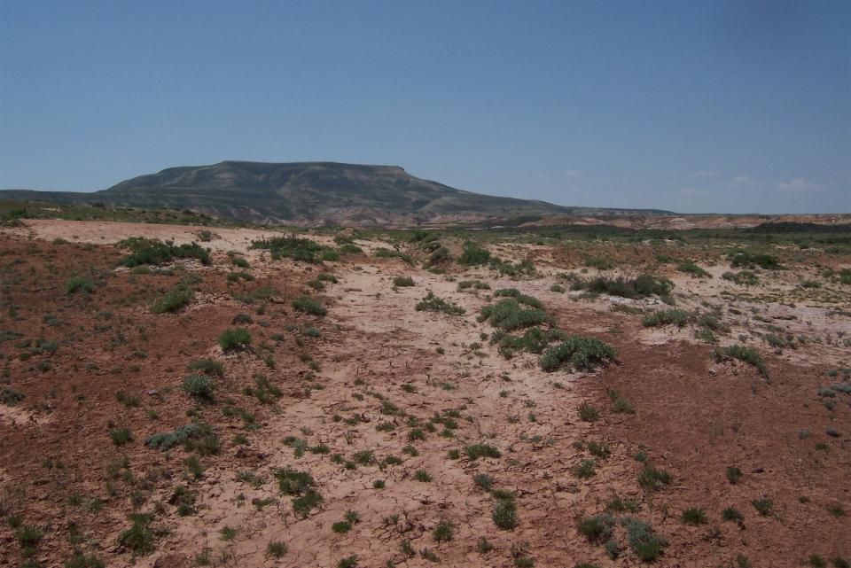
In 1850, one year after Evans’s Cherokee crossed the Red Desert, additional parties of Cherokee Indians and whites made the trip west to the California gold fields. They pioneered a new route across Wyoming, the 1850 Southern Route (see Figures 1, 2 and 5). The Southern Route separated from the 1849 Evans Cherokee Trail near the Wyoming/Colorado border south of Laramie. The 1850 trail ran west through the Medicine Bow Mountains to the valley of the North Platte River (North Park) which it crossed south of the Wyoming/Colorado border. The Southern Route reentered Wyoming west of the North Platte River and crossed a large ridge system known as the Atlantic Rim. The trail followed a series of landmarks including crossing the Continental Divide at the Twin Groves, a group of small conical hills known as the Five Buttes (Figure 6), a drainage now known as Muddy Creek, a large plateau now named North Flat Top Mountain (Figure 7), and an east-to-west trending ridge system known as Powder Rim located near the Colorado border (Figure 8).
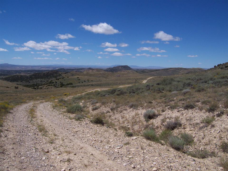
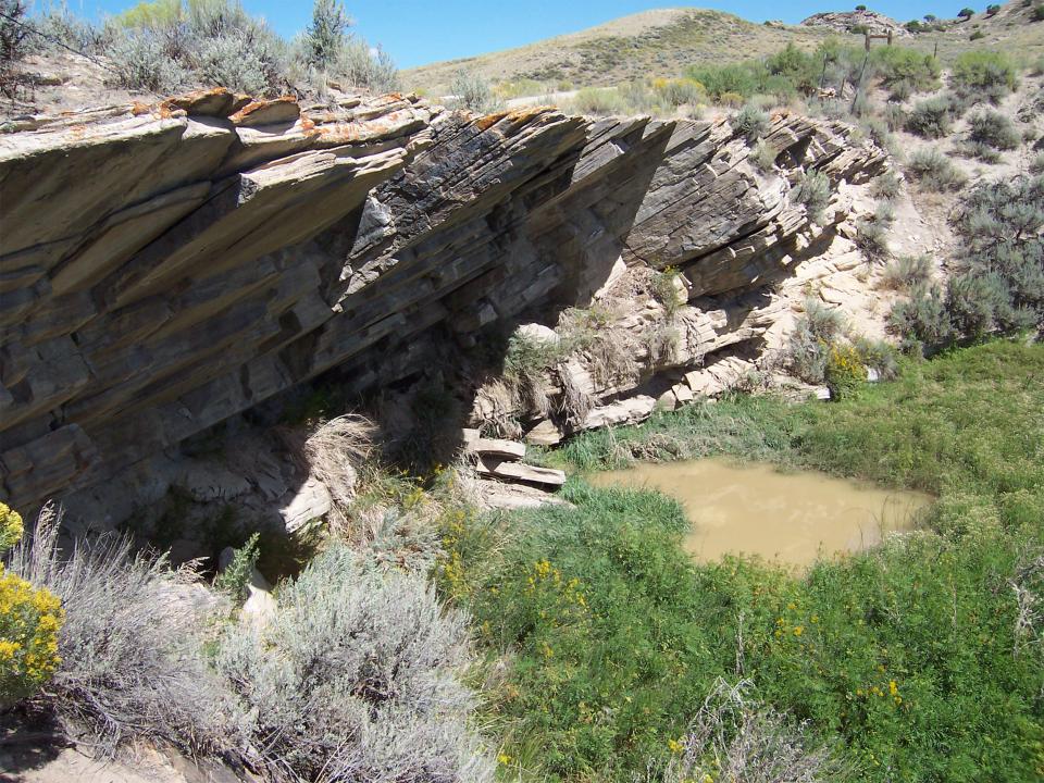
Powder Rim led to a sulphur spring known today as Lower Powder Spring (Figure 9). From Lower Powder Spring, the trail continued west crossing the Green River approximately 15 miles south of present Green River, Wyoming. The trail then divided with one variant running north along the Blacks Fork River joining the Oregon Trail near modern Granger. The second variant ran west to Fort Bridger (Figure 10). Evidence for the location of the Southern Route is found in Cherokee Creek west of the Atlantic Rim, a second Cherokee Creek, the east and west forks of Cherokee Draw, Cherokee Basin and Cherokee Rim located east of Powder Rim.
Origins of the Southern Route, 1839-1844
The Cherokee Trail Southern Variant was first developed in the 1830s as part of the fur trade. Fur trappers worked the streams and rivers through the region beginning in the 1820s. By the 1830s pack trains were moving between competing fur trade posts along the South Platte River near modern Denver and the Hudson’s Bay Company post at Fort Hall, in present Idaho. In 1837, this traffic was enhanced by the building of Fort Davy Crockett a fur trade post located along the Green River in Browns Park, northwestern Colorado.
Travelers including E. Willard Smith, Frederick Wislizenus and Robert Shortess described crossing this area in 1839 although their routes differed somewhat from the later Cherokee Trail. In 1841, Jim Bridger established a trading post on the Green River between the Blacks Fork and Henry’s Fork Rivers to become involved in this trade. Hostile groups of Sioux, Cheyenne, and Arapaho people moved through this area during the 1830s and 1840s. Robert Shortess and E. Willard Smith described fur trappers battling Indians along the Little Snake River in 1839. In 1841 a party of fur trappers and hunters led by Bridger's partner Henry Fraeb was attacked on Muddy Creek and Fraeb was subsequently killed along the Little Snake River near modern Dixon, Wyoming.
In 1842, Fort Davy Crockett was abandoned due to Indian hostility and Bridger moved his trading post to the Bridger Valley in Uinta County. Other than explorer John C. Fremont who crossed the area in 1844, there is little evidence of traffic through this region for the rest of the 1840s. Emigrant traffic had shifted to the Oregon Trail.
In 1850, Cherokee emigrants created the Southern Route. It largely followed the earlier trapper’s route until it reached Muddy Creek. Instead of following Muddy Creek south to the Little Snake River, it continued west crossing North Flat Top Mountain and Powder Rim. It is unclear why the Cherokee Indians chose to cross the rugged and largely waterless upland areas of North Flat Top Mountain and Powder Rim rather than to travel south to the Little Snake River and follow it west.
One possibility is that fear of Indian attack convinced the emigrants to use the upland route. Indian attacks in 1839, 1841 and 1842 indicated that the area west of the Continental Divide was hazardous. In the fall of 1850 upon reaching Muddy Creek on what would become the Overland Trail, Capt. Stansbury issued a standing order to his expedition that no guns should be discharged without his specific command to avoid alerting hostiles to their presence. Stansbury’s guide, Jim Bridger knew how dangerous the area remained. It is possible that the 1850 Cherokee Indian companies chose the more difficult and waterless upland route along North Flat Top Mountain and Powder Rim to avoid the more exposed and potentially dangerous route along the Little Snake River. Cherokee Indian John Lowery Brown wrote about a camp on the east end of Powder Rim in 1850:
“[July] 12 We traveled 5 miles and came to where Capt Home’s Co. were camped which was 1-1/2 miles from the Yamper River [Little Snake River]. A great many Indians were coming into camp as we got there which caused great excitement. They came up Friendly. They proved to be the Snake Indians. Capt Homes reported that he had been 8-10 miles and could find no water or grass, so we all concluded to stay where we were carelled [corralled] together. [word illegible] carried [herded] our stock to the R[iver] to graze and packed water from the same place 1-1/2 miles”.

It is unclear how much the 1850 Cherokee Indian parties knew of the 1830s and early 1840s hazards along the southern route which Jim Bridger still remembered. The Cherokee were clearly anxious about the presence of Indians in the area. They preferred to haul water 1½ miles rather than camp on the Little Snake River.
Calvin Hall Holmes Variant, 1854
In 1854, the worst parts of the Southern Route including North Flat Top Mountain and Powder Rim were replaced by a new route. This trail is known as the Holmes Variant after its founder Calvin Hall Holmes who pioneered the route in 1854. He is the Capt. Homes mentioned by John Lowery Brown in 1850. The Holmes Variant followed the Southern Route across the Atlantic Rim to Muddy Creek. Instead of crossing Muddy Creek, the new route turned south and followed the fur trapper route down Muddy Creek some 25 miles to an intersection with the Little Snake River near modern Baggs, Wyoming (see Figure 5). The trail entered Colorado and turned west to follow the Little Snake River to the mouth of a dry wash known as Powder Wash. The trail followed Powder Wash for 16 miles to Lower Powder Spring where it reentered Wyoming and rejoined the 1850 Southern Route. Holmes compared his new route with the Southern Route along which he had traveled in 1850.
“Thursday, [June] 29th. [1854]
Came a cross [Little] Snake River & down 5 miles and camped. This road is one we made and much the best as the one over the hills is out of the way and very hilly.”
This new route had the advantage of following the Little Snake River, a good source of water and avoiding some of the worst grades along the trail including North Flat Top Mountain. It was however, somewhat longer than the Southern Route. The fear of Indian attack along the Little Snake River suggested by John Lowery Brown in 1850 must have abated by 1854.
On the trail in the 1850s
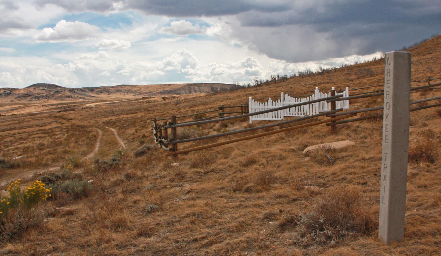
Travel on the Cherokee Trail across Wyoming was never easy. The trail had numerous long stretches with little or no good water, grass, or timber, and the route frequently involved steep slopes and ridges. Unlike the Oregon Trail, the Cherokee Trail in Wyoming rarely followed major rivers but crossed them at right angles with long dry stretches in between. Unlike the Oregon Trail and the Overland Trail, the Cherokee Trail did not have trading posts, military outposts, or stage stations supplying water, meals, supplies, and assistance. Through the 1850s and 1860s there were no settlements along the Cherokee Trail between eastern Colorado and Fort Bridger. Other than fellow travelers, there was no help to be found on the Cherokee Trail (Figure 11).
The Peculiar Institution, 1849-1862
One aspect of the Cherokee Trail which receives little attention is the presence of enslaved Black people on the trail in the pre-Civil War period. Before the Civil War, the Cherokee Trail originated in states permitting slavery. The roster for one 1849 group using the Cherokee Trail was listed as ... "128 souls, 3 of those women 2 Boys and 4 Nigroes" [sic].
The Evans/Cherokee companies of 1849 brought five unnamed enslaved people with them. The 1850 companies including John Lowery Brown's included 15 enslaved Black people, one of whom was a man named Runaway Tuff no doubt due to his efforts to escape slavery. John Lowery Brown himself brought a young, enslaved Black man named Jonas with him. Because California was a free state, enslaved people could gain their freedom when they entered the state. Tragically, neither Jonas nor Runaway Tuff survived the journey and obtained their freedom. Both men died of cholera along the Humboldt River in Nevada.
The Cherokee Trail in the late nineteenth century
The heyday for the Cherokee Trail was the 1850s. In the early 1860s, things began to change along the trail. The Cherokee Trail had been the route west for people from the southern United States to the California gold fields. By 1862, these areas were embroiled in the Civil War. Union victories at Pea Ridge in March 1862 and Prairie Grove in December 1862 had secured Union control of Missouri and in 1863, much of Arkansas was also under Union occupation. The Indian Territory was bitterly divided between Union and Confederate supporters and violence between Indian groups was endemic throughout the Civil War. The Cherokee Nation was laid waste and refugees streamed into Kansas. Kansas, Nevada and California were or became Union states and what are now Colorado, Wyoming and Utah were firmly under Union control. The Cherokee Trail saw little traffic during this period. The Oregon and Overland Trails remained the principal routes west. The Oregon and Overland Trails maintained stagecoach, mail, and telegraph service which the Cherokee Trail never had. No stage stations or trading posts were built along the Cherokee Trail in Wyoming except where it overlapped the Overland Trail in the 1860s. Throughout the 1860s Indian attacks were common on the Oregon and Overland Trails. Soldiers patrolled both routes and were posted to many stage stations. There is little evidence of Indian attacks on Cherokee Trail emigrants and no evidence that soldiers ever patrolled the Evans or Southern Routes or established military posts along them.
Following the end of the Civil War, the Oregon and Overland Trails continued to see emigrant traffic even after the completion of the Union Pacific Railroad in 1869. On the Cherokee Trail cattle and sheep drives became more common in the post-Civil War period. The Red Desert became important winter sheep range. Sheep drives originating in Oregon and California brought large flocks into Wyoming over portions of the 1849 Evans Route and the 1850 Southern Route. The 1850 Southern Route and especially the 1854 Holmes variant were used by local ranchers moving cattle through northwestern Colorado and southern Wyoming before being replaced by newer roads around the turn of the century. The Evans Route between Rawlins and Rock Springs was followed by the Union Pacific Railroad in 1868, the Lincoln Highway in 1913, and I-80 in the 1960s.
One popular story associated with the Cherokee Trail tells the tale of a party of Cherokee people and their cattle who spent the winter of 1849/1850 in Browns Park, Colorado. The next spring, the Cherokees resumed their journey west to California. This story is found in modern histories of the Cherokee Trail and Browns Park. Travel between the 1849 Evans Route and Browns Park was not practical given the two areas were separated by nearly 100 miles. Traveling between the 1850 Southern Route and Browns Park was entirely plausible. The distance between Lower Powder Spring and Irish Canyon, the eastern entrance to Browns Park from the north, is approximately 25 miles. The route was well known to fur trappers in the 1830s. Frederick Wislizenus, and E. Willard Smith traveled this way in 1839 and John C. Fremont made this trip in 1844.
The problem with the story of the Cherokee in Browns Park is that no known nineteenth century documents confirm it. The historic basis for this story is unclear. Is it possible that Cherokee people spent the winter in Browns Park but that no record of it has been found? Or is the story entirely folklore? Is it possible that the story is a confused memory of fur trappers at Fort Davy Crockett in the 1830s? Whatever the truth is, it shows that there is still much to learn of the Cherokee Trail in Wyoming.
[Editors’ note: Special thanks to the Wyoming Cultural Trust Fund, support from which helped make publication of this article possible.]
Resources
Primary Sources
- Farnham, Thomas J. Travels in the Great Western Prairies: The Anahuac and Rocky Mountains and in the Oregon Territory. Library Division, Provincial Archives of British Columbia, Canada, 1843, accessed March 20, 2024 at https://www.google.com/books/edition/Travels_in_the_Great_Western_Prairies/z3IBAAAAQAAJ?hl=en&gbpv=1&pg=PP9&printsec=frontcover.
- 4Fletcher, Patricia K.A., Jack E. Fletcher, and Lee Whiteley. Cherokee Trail Diaries. Volume I 1849, A New Route to the California Gold Fields; Volume II 1850, A New Route to the California Gold Fields. Caldwell, Idaho: The Fletcher Family Trust, The Caxton Printers Ltd., 1999.
- Fletcher, Jack E., and Patricia K.A. Fletcher. Cherokee Trail Diaries: Volume III, Emigrants, Gold Seekers, Cattle Drives, and Outlaws. Dexter, Michigan: The Fletcher Family Trust, Thomson-Shore Inc., 2001.
- Fremont, John C. Fremont’s First Impressions: The Original Report of His Exploring Expeditions of 1842-1844.Introduction by Anne F. Hyde. Lincoln: University of Nebraska Press, Bison Books, 2012.
- Hafen, LeRoy R. and Ann W. Hafen. To the Rockies and Oregon, 1839-1842. Glendale, California: The Arthur H. Clark Company, 1955.
- Madsen, Brigham D. Exploring the Great Salt Lake: The Stansbury Expedition of 1849 to 1850. Salt Lake City: University of Utah Press, 1989.
- National Archives. Record Group 77: Records of the Office of the Chief of Engineers National Archives Identifier 305806, Plans of Military Posts in the United States, 1840–1947. Fort Bridger Military Reservation 1871, accessed March 18, 2024 at https://www.archives.gov/findingaid/stat/discovery/77.
- U.S. Congress. House. J. Bartleson. Executive Documents, The House of Representatives Second Session of the Thirty-Fifth Congress 1858-1859 Vol II, Report of the Secretary of War. J. Bartleson. Diary of a Trip from Fort Bridger, Utah Territory, via Bridgers Pass and Laramie Plain to Fort Laramie, Nebraska Territory. Washington D.C.: James B. Stuman, Printer, 1859, accessed March 18, 2024 at https://www.govinfo.gov/app/details/SERIALSET-00999_00_00-001-0000-0000.
- U.S. Congress. House. W.W. Loring. “Colonel Loring to Army Headquarters, Camp Scott, Utah Territory, June 11, 1858.” in Executive Documents, The House of Representatives Second Session of the Thirty-Fifth Congress 1858-1859 Vol II, Report of the Secretary of War, Washington D. C.: James B Stuman Printer. 1859.
- U.S. Congress. House. Executive Documents, The House of Representatives Second Session of the Thirty-Fifth Congress 1858-1859 Vol II, Report of the Secretary of War. Washington, D.C.: James B Stuman, Printer, 1859a.
- U.S. Congress. House. Executive Documents, The House of Representatives Second Session of the Thirty-Fifth Congress 1858-1859 Vol V, Maps. Washington, D.C.: James B Stuman Printer, 1859b, accessed March 18, 2024 at https://www.govinfo.gov/app/details/SERIALSET-00999_00_00-001-0000-0000.
- U.S. Department of War. The prairie traveler. A hand book for overland expeditions. With Maps, illustrations, and itineraries of the principal routes between the Mississippi, and the Pacific. Randolph B. Marcy. New York: Harper & Brothers, 1861, accessed March 17, 2024 at https://www.loc.gov/resource/gdcmassbookdig.prairietravelerh01marc/?st=gallery.
- Wislizenus, Frederick A. “A Journey to the Rocky Mountains in the Year 1839.” Reprint from the collection of the University of Michigan Library. 1912. St. Louis, Missouri: Missouri Historical Society, accessed March 18, 2024 at https://www.loc.gov/item/13004342/.
Secondary Sources
- Burroughs, John R. Where the Old West Stayed Young. New York: Bonanza Books, 1962.
- The Cherokee Trail. Rock Springs, Wyoming: Western Wyoming Community College History Department website, 2002.
- Dunham, Dick, and Vivian Dunham. Flaming Gorge Country: The Taming of Daggett County, Utah. Manila, Utah: Daggett County Lions Club, 2005.
- Gardner, A. Dudley. Historic Survey of the Cherokee Trail. Archaeological Services, Western Wyoming College, Rock Springs, Wyoming, 1982. (Hereafter ASWWC)
- Gardner, A. Dudley, Debbie Allen, and David E. Johnson. Historic Assessment of the Cherokee Trail and Bryan to Browns Park Road Within the Wold Trona Lease Area (revised). ASWWC, Rock Springs, Wyoming, 2002.
- Johnson, David E., Robert G. Rosenberg, and A. Dudley Gardner. A Historical Assessment of the Overland Trail Segments from the Washakie Stage Station to Point of Rocks, Carbon and Sweetwater County, Wyoming. Western Archaeological Services, Rock Springs, Wyoming. 2005. (Hereafter WAS)
- Johnson, David E. Historical Assessment of Cherokee Trail Segments, Along Cherokee Creek, Wild Horse Basin, and Peach Orchard Flat, Carbon County, Wyoming. WAS, Rock Springs, Wyoming, 2006.
- _____________. Historical Assessment of Cherokee Trail Segments in the Continental Divide-Creston EIS Study Area, Carbon County, Wyoming. WAS, Rock Springs, Wyoming. 2008.
- _____________. Historical Assessment of the Cherokee Trail Segments Hangout Wash to Lower Powder Springs, Carbon and Sweetwater Counties, Wyoming. WAS, Rock Springs, Wyoming, 2011.
- Jones, Robert H. Guarding the Overland Trails: The Eleventh Ohio Cavalry in the Civil War. Spokane, Washington: The Arthur H. Clark Company, 2005.
- Josephy, Alvin M. Jr. The Civil War in the American West. New York: Vintage Books, a division of Random House Inc., 1993.
- Kouris, Diana A. The Romantic and Notorious History of Browns Park. Powell, Wyoming: Wolverine Gallery, 1988.
- Whiteley, Lee. The Cherokee Trail: Bent’s Old Fort to Fort Bridger. Boulder, Colorado: Johnson Printing, 1999.
Illustrations
- The 1871 map of the Fort Bridger Military Reservation is from the National Archives. Used with thanks.
- All the rest of the images are from Western Archeological Services in Rock Springs, Wyoming. Used with permission and thanks.