History of Glendo Dam
Few issues in the arid West are as contentious or complicated as water rights. Wyoming and Nebraska tangled over rights to the North Platte River as early as the 1880s, disputes that on occasion ended up in the U.S. Supreme Court. It took 11 years to resolve one lawsuit, the Supreme Court finally ruling in 1945 that Nebraska was entitled to 75 percent of the North Platte’s flow, and Wyoming entitled to 25 percent. When Wyoming’s Glendo Dam was authorized in 1944, it would operate under this Supreme Court decree, but there would be further complications.
The trouble with the North Platte is its disregard for state boundaries. While the river rises in the snowmelt of the Colorado Rocky Mountains, it flows north into Wyoming, and then curves sharply east, crossing into Nebraska northwest of Scottsbluff. When Glendo Dam was proposed, it was the latest of many dams already ringing the North Platte in Wyoming--Seminoe, Pathfinder, Alcova, and Guernsey (Kortes would be added in 1951; Gray Reef in 1961).
Proposed for a site 25 miles upstream from Guernsey Dam, Glendo was not originally intended to add to irrigation development. Its purpose was to help reduce loss of capacity in Guernsey Reservoir due to silting, when a reservoir’s water volume is reduced by the long-term deposit of mud and silt on its bottom. In addition, Glendo Dam would increase the region’s hydroelectric power by storing water released from upstream power plants, thereby letting those plants operate year round.
Although preliminary investigations for Glendo Dam and Reservoir began in 1944, competing state interests held construction up until December 1954. Nebraska feared Glendo Reservoir would reduce flow into Lake McConaughy at Ogallala, while Colorado thought the additional storage at Glendo might be grounds for it to request the use of more water in the state’s North Park region, headwaters of the North Platte.
It took an act of Congress, Public Law 841, to reveal just how heated a water question could become in the West. No money would be appropriated for any part of the Glendo project, Congress stated, until a definite plan for water use was agreed upon by the three states and approved by Congress.
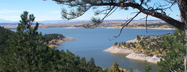
In 1954, the U.S. Bureau of Reclamation designed a plan that satisfied all involved, and bids for Glendo Dam were opened on November 9, 1954. Glendo Reservoir, all agreed, would be designed to store 800,000 acre feet of water (one acre foot is enough water to cover an acre of land to a depth of one foot).
The capacity then was divided--100,000 acre feet would be used for irrigation; 115,000 acre feet for sediment control; 275,000 acre feet for flood control; and 310,000 acre feet for power production. The agreement, further illustrating the complicated nature of water matters in the West, involved an amendment to the 1945 Supreme Court decree allocating the North Platte’s flow to Wyoming and Nebraska. The amendment provided that although 100,000 acre feet could be stored in Glendo Reservoir for irrigation, only 40,000 acre feet could be used in any one year--15,000 acre feet for Wyoming, and 25,000 acre feet for Nebraska. Additional hydroelectric power would serve both states, as well as Colorado.
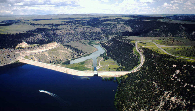
With legal matters settled, the C. F. Lytle and Greene Construction companies began excavation for Glendo Dam in mid-December 1954 and completed the dam in the early fall of 1957. Glendo is an earthfill dam, standing 190 feet high and with a crest length of 2,096 feet. On the south side of the reservoir, nearly a half-mile of dikes were necessary in a low area.
Construction also required relocating three miles of Chicago, Burlington, and Quincy Railroad tracks, and four miles of U.S. 87 (now part of Interstate 25), which runs along the west side of the reservoir. Glendo Dam and its power plant, situated on the North Platte River, are part of the Bureau of Reclamation’s Glendo Unit of the Pick-Sloan Missouri Basin Project.
This article was originally published as part of a National Park Service series, “Discover Our Shared Heritage Itinerary, Bureau of Reclamation’s Historic Dams and Water Projects, Managing Water in the West.” Used here with thanks.
Resources
For Further Reading
- "Dam Details—Glendo Dam—Bureau of Reclamation." Bureau of Reclamation website. Accessed January 12, 2013 at http://www.usbr.gov/projects/Facility.jsp?fac_Name=Glendo+Dam&groupName=Overview
- Bell, Tina. "Glendo Unit: Oregon Trail Division: Pick-Sloan Missouri Basin Program." Bureau of Reclamation, 1997.
- Cannon, Brian. Remaking the American Dream: New Deal Rural Resettlement in the Mountain West. Albuquerque: University of New Mexico Press, 1996.
- Kluger, James. Turning Water on With a Shovel: The Career of Elwood Mead. Albuquerque: University of New Mexico Press, 1992.
- Miller, Char. Fluid Arguments: Five Centuries of Western Water Conflict. Tucson: University of Arizona Press, 2001.
- Reisner, Marc. Cadillac Desert: The American West and its Disappearing Water. New York: Viking, 1986, reprint, New York, Penguin Books, 1993.
- "The Bureau of Reclamation: A Very Brief History." Bureau of Reclamation. Accessed February 1, 2013 at http://www.usbr.gov/history/borhist.html
- Worster, Donald. Rivers of Empire: Water, Aridity and the Growth of the American West. New York: Random House, 1965.
Illustrations
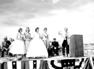
- The aerial photo of Glendo Dam and the picture of the 1957 dedication ceremonies are U.S. Bureau of Reclamation photos.
- The photo of the reservoir is by Wyoming State Parks and Cultural Resources. All are used with thanks.