Camping along the Early Lincoln Highway in Wyoming
In 2011, archaeologists from Western Archaeological Services in Rock Springs, Wyoming, recorded a historic campsite located along segments of the second- and third-generation Lincoln Highway in central Sweetwater County, Wyoming. The site is at the western edge of the Red Desert, between Rawlins, Wyoming, and Rock Springs. The Red Desert, or Great Divide Basin, is a large internally draining basin some 60 miles wide which the Lincoln Highway, in the early and mid-20th century, crossed from east to west. The Continental Divide splits and encircles the basin; water flows to neither the Atlantic or Pacific.
The campsite contains clusters of inscriptions carved by Lincoln Highway travelers on sandstone outcrops located off the road. These inscriptions date from the 1910s to the 1950s. There is also a scatter of historic artifacts including glass bottle fragments, tin cans and fragments of ceramic tableware. The site was an informal camping area which saw repeated use over the early years of the Lincoln Highway. Use declined when the third-generation Lincoln Highway replaced the second-generation route in 1937. When I-80 was built in the 1960s, the site was bypassed altogether and forgotten.
Phases of the Lincoln Highway
The Lincoln Highway was a work in progress over five decades from 1913 to construction of I-80 in the 1960s. The road was upgraded in segments within individual counties rather than all at once across the entire state. As motor vehicles became larger, faster and more powerful, the highway’s design changed to meet these advances. The route was moved, curves were straightened, the road was widened, grades were lowered and improved surfacing was added to allow for faster and safer travel.
Three distinct construction phases are generally referred to as the first, second and third generation highway. There are no fixed dates for these phases, as the highway was upgraded whenever specific segments were improved. The first generation refers to the original route designated by the national Lincoln Highway Association (LHA). This road dates from 1913 to the 1920s. It stitched together existing unimproved wagon roads or, where available, abandoned sections of the Union Pacific Railroad’s original 1868 transcontinental route. West of Granger, in southwestern Wyoming, the original Lincoln Highway used the Oregon Trail.
Little original construction was done on this early road. Wood and stone culverts and wooden bridges were built over arroyos, but these were often flimsy and could not bear the weight of heavy truck traffic. The railroad grades were very narrow: It was nearly impossible for oncoming traffic to pass. Cropping the crests of the railroad grades was necessary to widen them for two-way traffic.
The second-generation highway was designated by the LHA as a boulevard. It was a 24 feet wide, two-lane improved road, surfaced with gravel or crushed rock. By the 1930s the surface was often sprayed with oil. Macadam, an early form of road paving, was also used especially on sections prone to erosion. More substantial culverts and bridges were built over arroyos and large steel and concrete bridges crossed major rivers. Some second-generation segments not upgraded to third-generation status in the 1930s were paved with asphalt but were not otherwise altered or widened. Second-generation roads saw much new construction and new road alignments.
Third-generation routes were constructed from the 1930s and 1940s through the completion of I-80 in the 1960s. These roads were 36 feet wide, two-lane highways with broad shoulders. Third-generation segments were paved with asphalt or rarely with concrete. Some were upgraded second-generation routes; others were original construction.
Camping along the Lincoln Highway
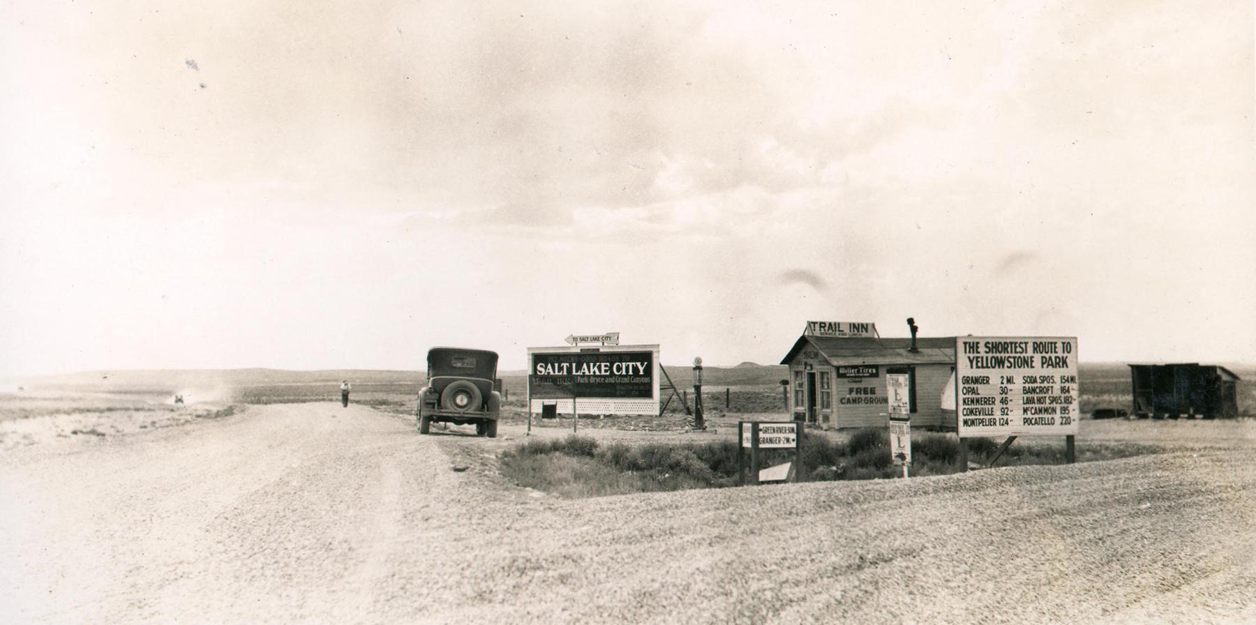
The development of the Lincoln Highway across Wyoming in the 1910s and 1920s necessitated the parallel development of a support infrastructure including tourist accommodations. Two forms of tourist accommodations were used: hotels and campgrounds. Existing hotels in the late 19th and early 20th centuries were built in town and city centers along or near the railroad tracks. These hotels served local patrons or people traveling by train and were poorly suited by location and design for automobile traffic. The 1916 Complete Official Road Guide of the Lincoln Highway listed 36 Wyoming communities along the Lincoln Highway between Pine Bluffs on the east and Evanston on the west.
Of these 36 towns, 17 (47 percent) had hotel accommodations for a total of 43 hotels. Twenty-seven hotels (63 percent) were located in major cities including Cheyenne, Laramie, Rawlins, Rock Springs, Green River and Evanston. Sixteen hotels were located in 11 smaller communities, either one or two to a town. There were five hotels located between Pine Bluffs and Cheyenne, no hotels between Cheyenne and Laramie, four hotels in three towns between Laramie and Rawlins, two hotels between Rawlins and Rock Springs, and five hotels in three towns between Green River and Evanston.
The other form of accommodation utilized by Lincoln Highway tourists was campgrounds. Lincoln Highway camping was initially a western feature due in part to the relatively small number of towns with hotels and the long distances and bad roads between them. Very few camping areas were located in eastern states because towns with hotels were numerous and closely spaced with better quality roads resulting in faster travel. The Lincoln Highway Association encouraged camping as a way of saving money and to deal with the lack of hotel accommodations across the West. The Lincoln Highway Official Road Guides published long lists of camping equipment which early motorists were advised to bring with them both for anticipated camping stops and unforeseen breakdowns. This list resembled lists of recommended supplies for a trip on the Oregon Trail in the 1850s.
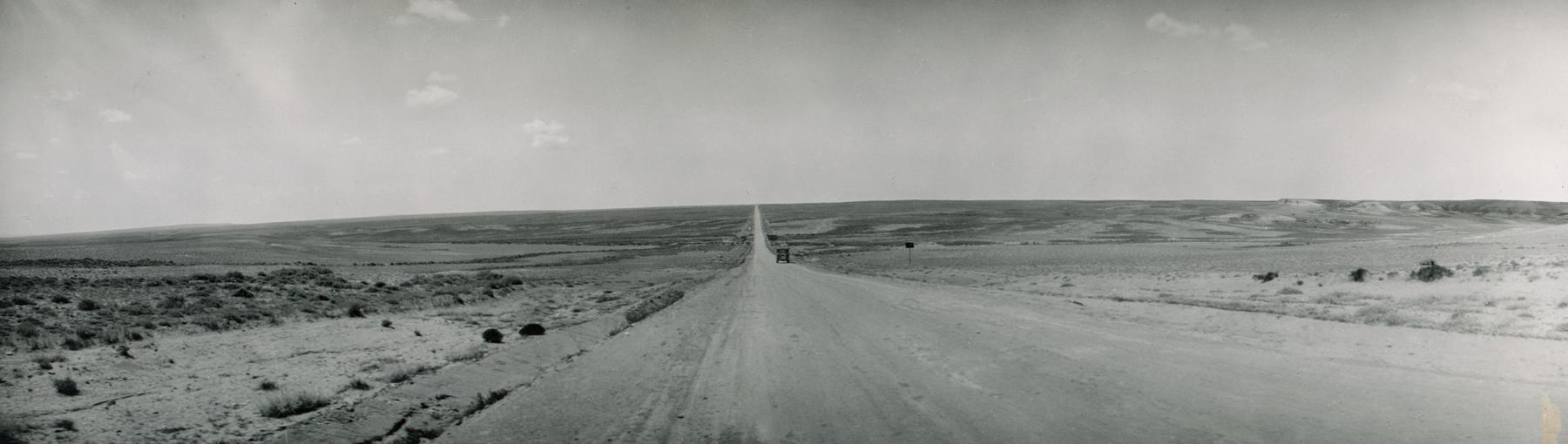
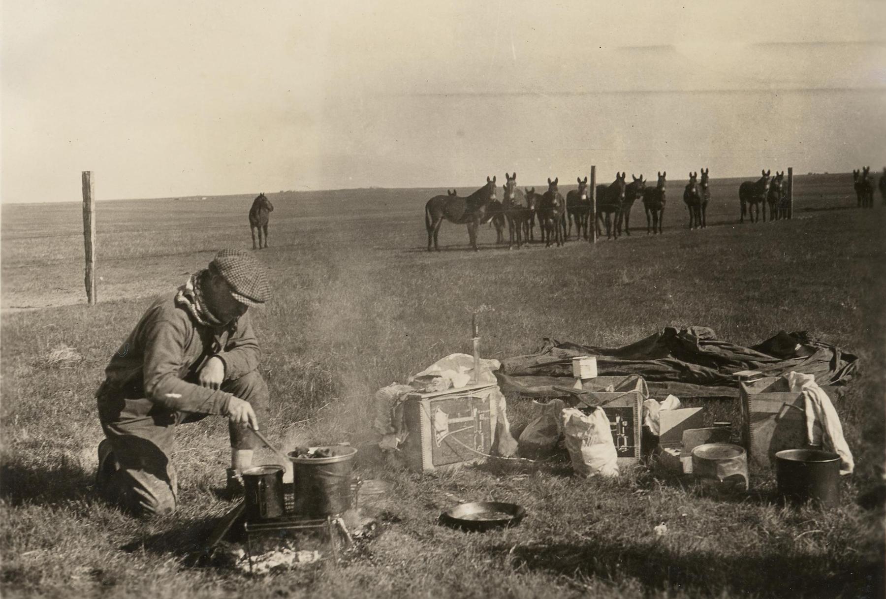
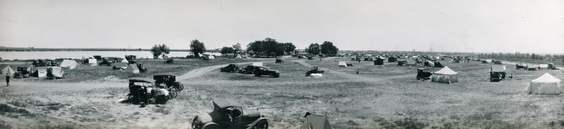
Like their Oregon Trail forebears, early Lincoln Highway motor campers in Wyoming saw most campsites as a point along the way, not as a destination. At first, campers simply parked along the side of the road (Figure 2). Because these stays were largely overnight, the lack of a formal campground was not overly important (Figure 3). Groceries could be purchased at any town and necessities such as water or firewood could be obtained from sympathetic ranchers or railroad camps.
Of the 36 communities between Pine Bluffs and Evanston, 18 (50 percent) had campsites by 1916. No campsites were located between Pine Bluffs and Cheyenne, or between Cheyenne and Laramie. There was camping in Cheyenne. The 13 communities between Laramie and Rawlins had 11 camping areas. Three of seven communities between Rawlins and Rock Springs and three of five communities between Green River and Evanston also had campsites. Most of these early camping areas were unimproved fields (Figure 4).
By 1920, it was estimated that one third of all Lincoln Highway motor tourists camped for part or all of their journey. It was becoming apparent that motor tourists had money to spend and it was of economic benefit to towns and cities to convince them to stop and spend it. Towns and cities began to build formal municipal campgrounds within city limits to entice tourists to spend time and money in their town.
Wyoming’s first significant Lincoln Highway municipal campground opened in Cheyenne in 1920 (Figure 5). Cheyenne was an important hub on the Lincoln Highway, as it was the junction with roads to Denver, Yellowstone Park and the Colorado Rockies. It was also a tourist destination hosting the Frontier Days Rodeo which attracted 10s of thousands of visitors each July.
The Cheyenne Municipal Campground became the largest and most elaborate campground along the Lincoln Highway in Wyoming. It came to include washing and cooking facilities, a store, a post office, tourist information, firewood and shelter from inclement weather. From 1920 to 1923, camping at the Cheyenne Municipal Campground was free. Expenses were covered by local businesses.
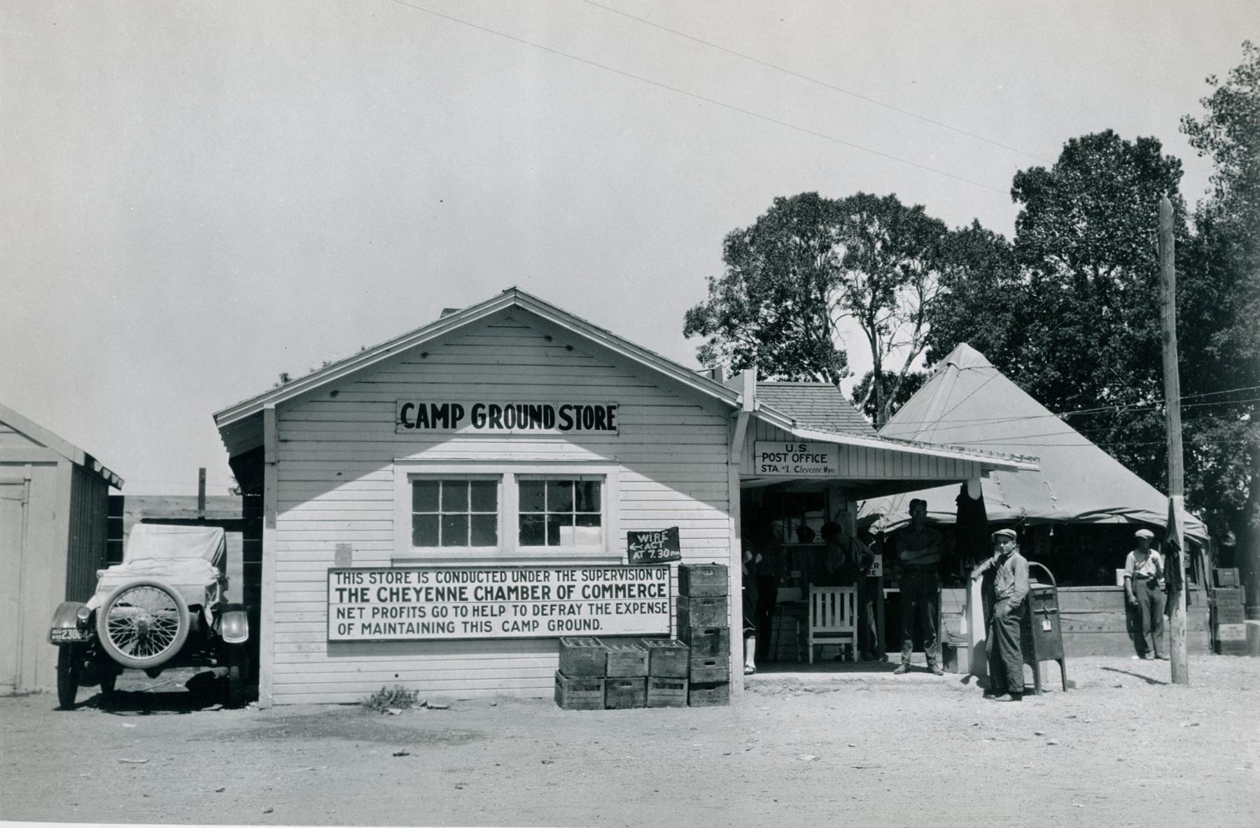
In 1923, the campground began to charge 50 cents per night—about a $9 value in 2024—to support the facilities and discourage squatters. The success of the Cheyenne Municipal Campground quickly inspired other cities and towns including Pine Bluffs, Laramie, Rock River, Rawlins, Rock Springs and Green River to build their own municipal campgrounds. These were also free, at least at first.
As municipal campgrounds grew and developed, towns tried to discourage roadside camping, which was seen as a health hazard as well as competition with formal campgrounds. In 1925, Cheyenne civic leaders coined the phrase “promiscuous camping” to describe tourists who set up camp in empty lots or in areas just outside the Cheyenne city limits in order to avoid paying the municipal campground fees. Roadside camps were seen as dangerous and dirty and, perhaps more important to urban leaders, showed a lack of civic spirit in not supporting the municipal campgrounds. Civic leaders began to lobby for ordinances prohibiting roadside camping.
By the late 1920s, tent campgrounds began to evolve into motor courts which consisted of small unfurnished wood frame cabins. Tourists had to supply their own cooking and sleeping gear. Like the tent camping grounds, motor courts began to add amenities including stores, gas stations, and washing and cooking equipment. After World War II, motels became the ultimate expression of tourist accommodations. But despite state and local laws and the interstate highway system, roadside camping never entirely disappeared.
Red Desert Lincoln Highway Campsite
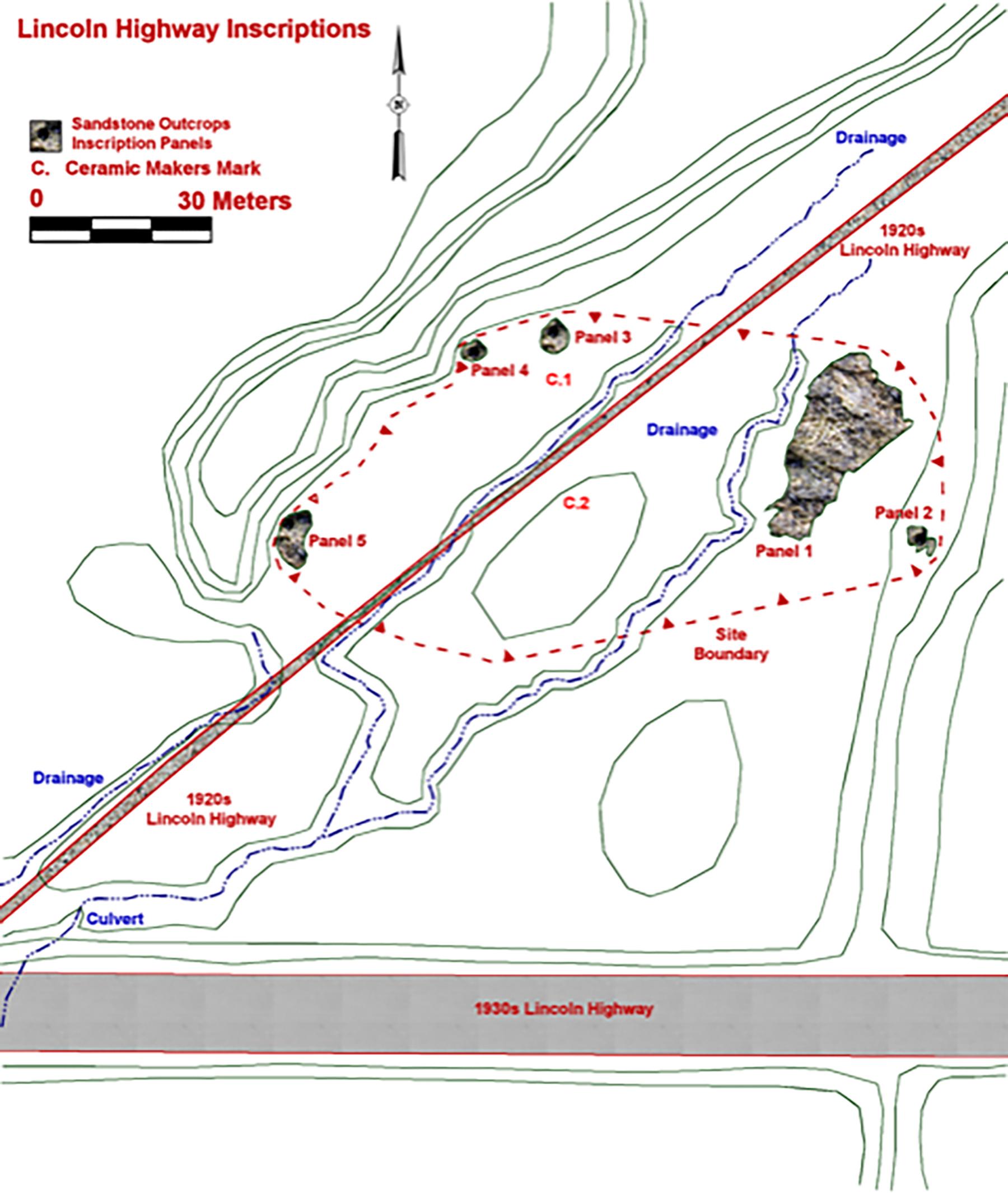
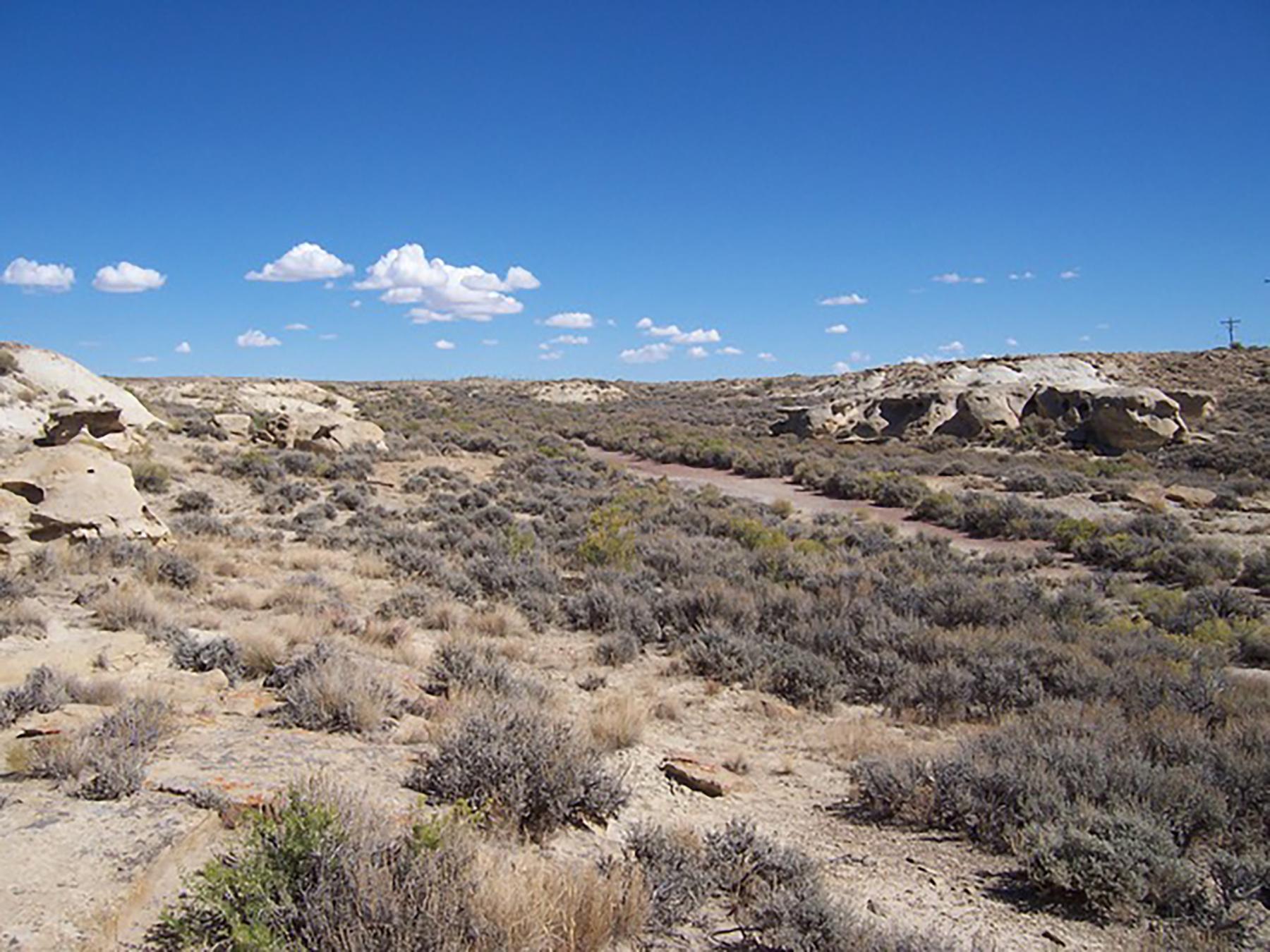
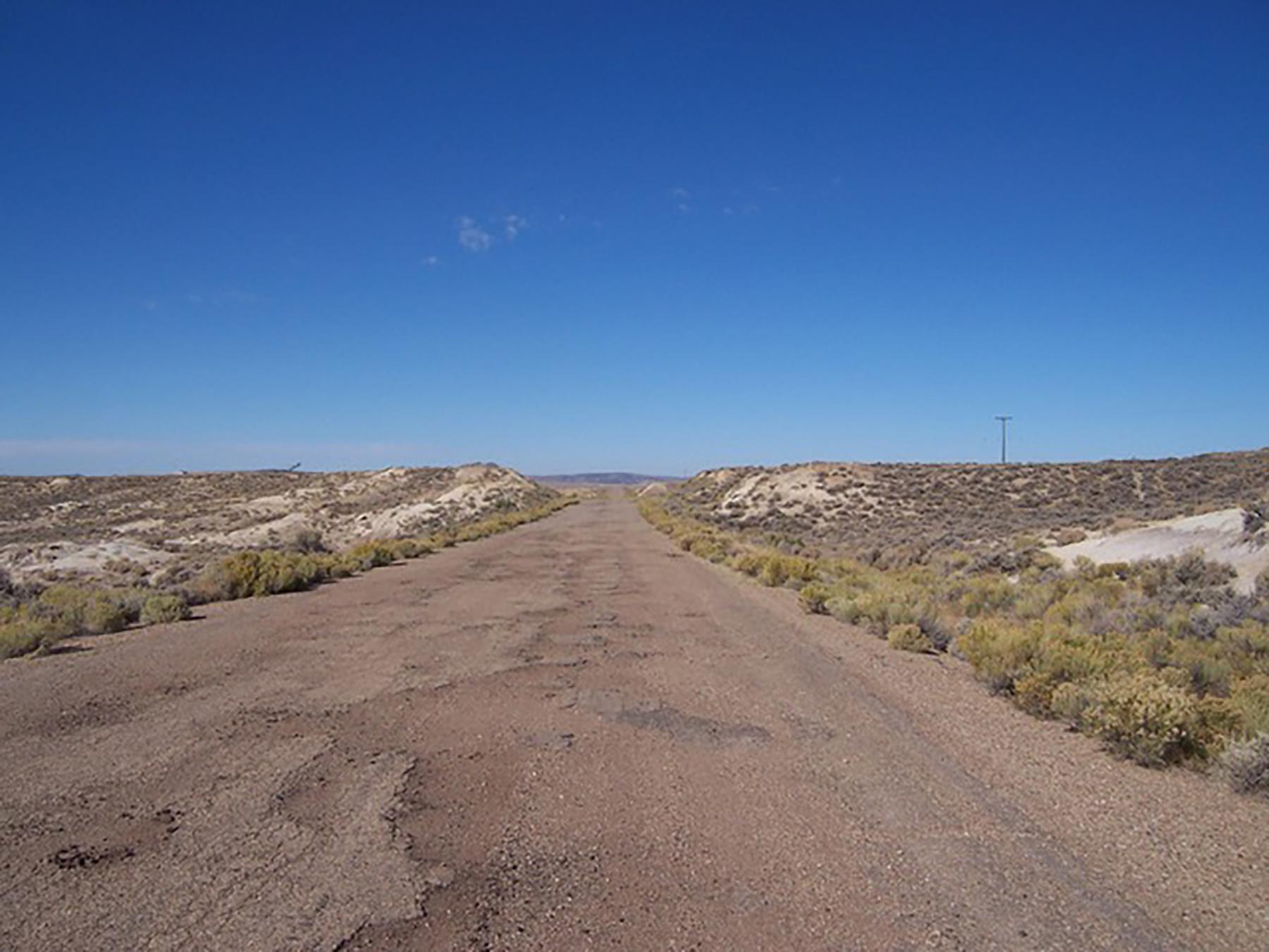
The Red Desert Lincoln Highway Campsite is located at the west edge of the Great Divide Basin. The site consists of an informal roadside camping area along the second and third generation segments of the Lincoln Highway. The second-generation highway segment consists of a two-lane boulevard built to 1920s Lincoln Highway standards. The route of the 1920s variant was originally surveyed in 1919 and followed the first-generation route. The highway consists of a 24-ft-wide, two-lane boulevard. The roadbed consists of a low berm with shallow barrow ditches to the east and west. The road has been surfaced with crushed rock gravel. Some asphalt is present at the south end of the segment near the crossing of the 1930s variant. It sees no modern traffic.
The third-generation segment consists of a two-lane paved highway built in 1937 to 1930s Lincoln Highway standards. The segment consists of a 36-ft-wide, two-lane highway paved with asphalt. Yellow center lines are still visible across much of the segment. The highway follows the existing terrain. However, shallow cuts are present along the crest of the finger ridges and fills are present across the bottoms of the valleys. The integrity of the asphalt paving and the presence of the yellow centerlines indicates that the segment was maintained up to the 1960s when it was replaced by I-80. The segment sees occasional modern traffic.
Inscription panels
The campsite consists of five sandstone rock outcrops containing historic inscriptions dating to the early 20th century and a scatter of historic artifacts which date to the same period. The inscriptions are located on either side of the second-generation Lincoln Highway. The third-generation segment of the Lincoln Highway is located approximately 150 feet south of the site. The inscriptions are located on five isolated sandstone outcrops designated Panels 1, 2, 3, 4 and 5. Panels 1 and 2 are located to the east of the 1920s Lincoln Highway segment, and Panels 3, 4 and 5 are located west of the road segment. Fragments of broken glass are present at the base of several of these outcrops indicating that these artifacts were used to carve at least some of the inscriptions.
Panel 1
The largest set of inscriptions is located on Panel 1, a large sandstone outcrop located to the east of the 1920s Lincoln Highway segment (Photo gallery figure 1). Panel 1 is an isolated sandstone outcrop approximately 105 feet long by 50 feet wide by 6 to 10 feet tall. The outcrop is located approximately 60 feet east of the 1920s Lincoln Highway segment. The inscriptions are concentrated along the south, southeast and southwest ends of the outcrop. The inscriptions consist of names and initials with a small number of locations, and several dates.
Dated inscriptions include B J 1918; S E Smith 1920; Victor Adones, Achaval Romero 1920; AR AT 1922; and SLC Utah 7.....25. Undated inscriptions include Miss Clara Moon Astoria O; .....Horn; the initials F. H. and D. W. enclosed in a square; the initials R F, N K, R. D, D B P, A M, M O; Mr. ......; L. J. Peters; and Bert Forgers; are also present. The Masonic emblem of the Square and Compasses with the letter G, and the inscription H. E. Co..an Mass is also present (gallery figure 2).
Panel 2
Panel 2 is located on a small isolated sandstone outcrop located approximately 40 feet east of Panel 1. Panel 2 is approximately 20 feet long by 12 feet wide by 6 feet tall (gallery figure 3). Inscriptions are found on all sides of the outcrop. Dated inscriptions include a rectangular box containing 1953; JL LA GL; N H 193.....; Archie Phrainen 818 West St. 1937; B H 1950; and Don Gonzales 1956; Undated inscriptions include W A H H ef; Shane loves Deborah; Kenneth; Albert; Henry Ukwertz; Hank; Julie; SL; HW; HRL; Scott; HAP; AA; RS; and a stylized Letter E (gallery figure 4). An incised figure of the lower torso, hips, and legs of a nude female figure is present on the north side of the outcrop. The upper torso has eroded away. A second figure is present to the right of the female figure.
Panel 3
Panel 3 is located to the west of the Lincoln Highway 1920s variant at the north end of the site (gallery figure 5). The panel, a small isolated sandstone outcrop, is located approximately 40 feet west of the highway segment at the base of the ridge forming the west side of the valley. The sandstone outcrop is approximately 15 feet long by 15 feet wide by five feet tall. Few inscriptions were noted on this outcrop. These include the initials L H, D G B, and TAN FNJ. No dated inscriptions or names were noted on this outcrop.
Panel 4
Panel 4 is a small sandstone outcrop located on the west side of the site, approximately 30 feet south of Panel 3 and 60 feet west of the Lincoln Highway segment (gallery figure 6). The outcrop is 12 feet long by 12 feet high by five feet wide. Only two inscriptions were noted on this outcrop. These include D Henr... likely D. Henry; and Mr. M..S.... This inscription was too badly eroded to be clearly legible. No names or dated inscriptions are present.
Panel 5
Panel 5 is a relatively large sandstone outcrop located west of the Lincoln Highway segment along the west side of the valley (gallery figure 7). The outcrop is located 100 feet south of Panel 4 and 30 feet west of the Lincoln Highway segment. The outcrop is 30 feet long by 15 feet wide by six feet tall. Inscriptions are located on the east, south and north sides of the outcrop. No dated inscriptions were noted. Inscriptions included St L H. Erp, Pulaski Wis; H Mildrd Giffod Park...ton Wyo; John P....; R S; Wilbur Jackson… Georgia (gallery figure 8).
Artifacts
In addition to the inscriptions, a scatter of historic artifacts was found across the site. Artifacts consist of food storage cans, glass bottle fragments and ceramic tableware. Glass bottle fragments include solarized amethyst glass, brown glass, white glass and clear glass bottle fragments. Solarized amethyst glass bottle fragments include one wide mouth rim from a milk bottle. Brown and clear glass bottle fragments were alcoholic or non-alcoholic beverage bottles. White glass fragments are from personal bottles, likely cold creams or lotions. Decorative glass fragments were also noted and are likely bowls or cups. Two identifiable bottle makers marks were found at this site. One dated between 1900 and 1929. The second dated between 1929 and 1954.
Ceramic tableware fragments were also present at this site. At least two plates are represented by the fragments. One was manufactured between 1914 and ca. 1925. The second dates from 1894 to 1909. In addition to glass and ceramics, tin can fragments were also noted. One hole-in-top can and six sanitary can fragments held fruits or vegetables. One evaporated milk can and one beer can which have been opened with a church key were also noted.
Conclusions
The artifacts and inscriptions found at this site indicate that this was an informal roadside campsite for Lincoln Highway motorists. The narrow valley and rock outcrops may have provided a welcome change from relatively ubiquitous scenery that had been seen during the long crossing of the Red Desert. Historical documents do not mention this area as a formal camp. No structural remains were noted. The dated inscriptions and diagnostic artifacts all point to the site being used during the early to mid-20th century.
Canned goods, evaporated milk, and beverage bottles and cans indicate that meals were prepared and consumed at this site. Meals including canned fruits or vegetables were served on ceramic plates and in glass bowls or cups. Alcoholic and nonalcoholic beverages were consumed. Lotion or cold cream bottles indicate personal health or hygiene was also practiced at the site.
While stopped at the site, motorists carved their names into the sandstone outcrops. The dates at Panel 1 range from 1918 to 1925 and the dates on Panel 2 range from the 1930s to 1956. The diagnostic bottles date from 1900 to 1929 and from 1929 to 1954. Ceramic plates date from 1894 to 1909 and 1914 to 1925. The inscription dates and the diagnostic artifacts all fall within the range of use of the first, second and third-generation variants of the Lincoln Highway.
Inscriptions by motorists from Pulaski, Wisconsin; Astoria, Oregon; Salt Lake City and possibly Massachusetts and Georgia show that people from across the country stopped here. No other cities or towns are located within eight miles of the site, making it unlikely that it is associated with a local settlement.
The Red Desert Roadside Campsite reflects an important aspect of early travel on the Lincoln Highway in Wyoming. Roadside camping grew out of a lack of alternate accommodations. The long distances, poor roads and lack of accommodations in the Red Desert led travelers to create this informal stop. Even the development of private and municipal campgrounds in the 1920s did not bring an end to roadside camping. It was a critical feature in early tourist travel, fulfilling a need which other available accommodations could not satisfy.
[Editor’s note: Special thanks to Wyoming Archaeological Services of Rock Springs, Wyoming, (the author’s employer), and to the Wyoming Cultural Trust Fund, support from which in part made publication of this article possible.]
Resources
Primary Sources
All newspapers accessed via the Wyoming Digital Newspapers Collection.
- Cheyenne State Leader, May 27, 1920, Page 7, Column 5, Cheyenne, Wyoming.
- Cheyenne State Leader, May 28, 1920, Page 1, Column 7, Cheyenne, Wyoming.
- Cheyenne State Leader, May 30, 1920, Page 2, Column 1, Cheyenne, Wyoming.
- Cheyenne State Leader, June 6, 1920, Page 3, Column 3, Cheyenne, Wyoming.
- Cheyenne State Leader, June 15, 1920, Page 1, Column 2, Cheyenne, Wyoming.
- Cheyenne State Leader, June 20, 1920, Page 2, Column 2, Cheyenne, Wyoming.
- Cheyenne State Leader, May 27, 1920, Page 7, Column 5, Cheyenne, Wyoming.
- Cheyenne State Leader, July 23, 1920, Page 1, Columns 3-4, Cheyenne, Wyoming.
- Cheyenne State Leader, May 27, 1920, Page 7, Column 5, Cheyenne, Wyoming.
- Cheyenne State Leader, Aug. 5, 1920, Page 6, Column 6, Cheyenne, Wyoming.
- Cheyenne State Leader, Aug. 6, 1920, Page 4, Columns 1-2, Cheyenne, Wyoming.
- Cheyenne State Leader, Aug. 19, 1920, Page 4, Column 6, Cheyenne, Wyoming.
- Cheyenne State Leader, Sept. 7, 1920, Page 1, Column 4, Cheyenne, Wyoming.
- Cheyenne State Leader, Oct. 12, 1920, Page 3, Column 5, Cheyenne, Wyoming.
- Cheyenne State Leader, Oct. 16, 1920, Page 3, Columns 3-6, Cheyenne, Wyoming.
- Cheyenne State Leader, Oct. 29, 1920, Page 5, Column 3, Cheyenne, Wyoming.
- Cheyenne State Leader, Jan. 1, 1921, Page 16, Columns 1-3, Cheyenne, Wyoming.
- Cheyenne State Leader, March 2, 1921, Page 6, Column 2, Cheyenne, Wyoming.
- The Encampment Echo, Sept. 9, 1920, Page 7, Column 2, Encampment, Wyoming.
- The Green River Star, Aug.3, 1917, Page 8, Column 3, Green River, Wyoming,
- The Green River Star, Aug. 31, 1917, Page 1, Column 2, Green River, Wyoming,
- The Green River Star, Feb.18, 1921, Page 1, Column 4, Green River, Wyoming,
- The Laramie Boomerang, June 15, 1920, Page 5, Column 3, Laramie, Wyoming.
- The Laramie Boomerang, Aug. 3, 1920, Page 7, Column 2, Laramie, Wyoming.
- The Laramie Boomerang, June 15, 1920, Page 5, Column 3, Laramie, Wyoming.
- The Laramie Boomerang, May 28, 1921, Page 4, Column 5, Laramie, Wyoming.
- The Laramie Boomerang, July 19, 1922, Page 8, Column 4, Laramie, Wyoming.
- The Laramie Republican, May 12, 1920, Page 2, Column 1, Laramie, Wyoming.
- The Laramie Republican, May 13, 1920, Page 1, Column 1, Laramie, Wyoming.
- The Laramie Republican (Semi-Weekly), June 5, 1920, Page 5, Column 5, Laramie, Wyoming.
- The Laramie Republican, Feb. 2, 1921, Page 2, Column 1, Laramie, Wyoming.
- The Laramie Republican (Semi-Weekly), May 6, 1922, Page 4, Column 4, Laramie, Wyoming.
- The Laramie Republican (Semi-Weekly), June 24, 1922, Page 7, Column 1, Laramie, Wyoming.
- The Laramie Republican (Semi-Weekly), July 1, 1922, Page 8, Column 4, Laramie, Wyoming.
- The Laramie Republican, July 7, 1922, Page 6, Columns 3-4, Laramie, Wyoming.
- The Laramie Republican, Sept. 26, 1922, Page 1, Column 5, Laramie, Wyoming.
- The Rawlins Republican, July 13, 1920, Page 1, Column 4, Rawlins, Wyoming.
- The Rawlins Republican, April 14, 1921, Page 6, Columns 1-2, Rawlins, Wyoming.
- The Rawlins Republican, July 14, 1921, Page 1, Column 1, Rawlins, Wyoming.
- The Rawlins Republican, July 21, 1921, Page 2, Column 1, Rawlins, Wyoming.
- The Rawlins Republican, Aug. 4, 1920, Page 6, Column 1, Rawlins, Wyoming.
- The Rawlins Republican, Aug. 11, 1921, Page 10, Columns 3-4, Rawlins, Wyoming.
- The Rawlins Republican, Sept. 1, 1921, Page 4, Column 1, Rawlins, Wyoming.
- The Rawlins Republican, April 27, 1922, Page 1, Column 1, Rawlins, Wyoming.
- The Rawlins Republican, July 13, 1922, Page 11, Column 3, Rawlins, Wyoming.
- The Rawlins Republican, July 20, 1922, Page 1, Column 4, Rawlins, Wyoming.
- Rock River Review, July 9, 1920, Page 1, Column 4, Rock River, Wyoming.
- Rock Springs Rocket, July 19, 1912, Page 1, Column 4, Rock Springs, Wyoming.
- Rock Springs Rocket, June 4, 1920, Page 5, Column 3, Rock Springs, Wyoming.
- Rock Springs Rocket, May 20, 1921, Page 1, Column 4, Rock Springs, Wyoming.
- Rock Springs Rocket, May 20, 1921, Page 7, Column 3, Rock Springs, Wyoming.
- Rock Springs Rocket, June 17, 1912, Page 2, Columns 4-6, Rock Springs, Wyoming.
- Rock Springs Rocket, May 12, 1922, Page 5, Column 1, Rock Springs, Wyoming.
- Rock Springs Rocket, Sept. 29, 1912, Page 1, Column 6, Rock Springs, Wyoming.
- Rock Springs Miner, Aug. 23, 1918, Page 1, Column 2, Rock Springs, Wyoming.
- Rock Springs Miner, April 29, 1918, Page 1, Column 4, Rock Springs, Wyoming.
- The Saratoga Sun, Aug. 16, 1917, Page 3, Column 1, Saratoga, Wyoming.
- Wyoming State Tribune, May 4, 1920, Page 3, Column 1, Cheyenne, Wyoming.
- Wyoming State Tribune, May 28, 1920, Page 5, Column 2, Cheyenne, Wyoming.
- Wyoming State Tribune, June 3, 1920, Page 2, Column 1, Cheyenne, Wyoming.
- Wyoming State Tribune, July 22, 1920, Page 1, Column 2, Cheyenne, Wyoming.
- Wyoming State Tribune, July 26, 1920, Page 5, Column 4, Cheyenne, Wyoming.
- Wyoming State Tribune, July 28, 1920, Page 1, Columns 3-4, Cheyenne, Wyoming.
- Wyoming State Tribune, May 13, 1921, Page 7, Columns 1-6, Cheyenne, Wyoming.
- Wyoming State Tribune, Aug. 26, 1921, Page 5, Columns 3-5, Cheyenne, Wyoming.
- Wyoming State Tribune, May 7, 1922, Page 1, Columns 5-7, Page 16, Column 3-4, Cheyenne, Wyoming.
- Wyoming State Tribune, June 25, 1922, Page 5, Column 4, Cheyenne, Wyoming.
- Wyoming State Tribune, Cheyenne State Leader, May 11, 1925, Page 4, Columns 1-2, Cheyenne, Wyoming.
- Wyoming State Tribune, Cheyenne State Leader, May 15, 1925, Page 4, Columns 1-2, Cheyenne, Wyoming.
- Wyoming State Tribune, Cheyenne State Leader, May 18, 1925, Page 1, Columns 1-2, Cheyenne, Wyoming.
- Wyoming State Tribune, Cheyenne State Leader, June 17, 1925, Page 4, Columns 1-2, Cheyenne, Wyoming.
- Wyoming State Tribune, Cheyenne State Leader, June 18, 1925, Page 4, Columns 1-2, Cheyenne, Wyoming.
- Wyoming State Tribune, Cheyenne State Leader, July 19, 1925, Page 4, Columns 1-2, Cheyenne, Wyoming.
- Wyoming State Tribune, Cheyenne State Leader, July 30, 1925, Page 4, Columns 1-2, Cheyenne, Wyoming.
- Wyoming State Tribune, Cheyenne State Leader, Jan. 14, 1926, Page 3, Column 2, Cheyenne, Wyoming.
- Wyoming State Tribune, Cheyenne State Leader, March 2, 1926, Page 4, Columns 1-2, Cheyenne, Wyoming.
- Wyoming State Tribune, Cheyenne State Leader, April 1, 1926, Page 6, Columns 1-2, Cheyenne, Wyoming.
- Wyoming State Tribune, Cheyenne State Leader, April 4, 1926, Page 4, Columns 1-2, Cheyenne, Wyoming.
- Wyoming State Tribune, Cheyenne State Leader, April 28, 1925, Page 4, Columns 1-2, Cheyenne, Wyoming.
- Wyoming State Tribune, Cheyenne State Leader, July 27, 1926, Page 4, Columns 1-2, Cheyenne, Wyoming.
- The Wyoming Labor Journal, Sept. 3, 1926, Page 12, Column 1, Rock Springs, Wyoming.
- The Wyoming Labor Journal, Sept. 2, 1927, Page 19, Column 2, Rock Springs, Wyoming.
- The Wyoming Press, Feb. 12, 1927, Page 2, Column 1, Evanston, Wyoming.
Secondary sources
- Appendix B, Historic Trails, in Class III Cultural Resource Inventory for the Questar Overthrust Pipeline Company, Main Line 133 Loop Expansion Project, Rock Springs Segment, Sweetwater County, Wyoming. Western Archaeological Services, Rock Springs, Wyoming. 2009.
- Class III Cultural Resource Inventory Report for the Samson Resources Company Marianne 2-17 Additional Access Road Sweetwater County, Wyoming. Western Archaeological Services, Rock Springs, Wyoming 2011b.
- Frankus, Jennie and David Johnson. Class III Cultural Resource Inventory Report for the Black Butte Coal Company Pipeline Relocation Block Inventory Sweetwater County, Wyoming. Western Archaeological Services, Rock Springs, Wyoming, 2012.
- Franzwa, Gregory M. The Lincoln Highway Wyoming, Volume 3. Tucson, Arizona: The Patrice Press, 1999.
- Historical Assessment of Lincoln Highway Segments From the I-80/U.S. 191 South Intersection to Green River, Sweetwater County, Wyoming. Western Archaeological Services, Rock Springs, Wyoming 2011a.
- Historical Assessment of the Lincoln Highway and 1868 Union Pacific Railroad Segments: Continental Divide-Creston EIS Study Area, Sweetwater County, Wyoming. Western Archaeological Services, Rock Springs, Wyoming, 2008.
- Jackson, E. R. Report on the First Transcontinental Motor Convoy. 1919. Manuscript on file, Dwight D. Eisenhower Presidential Library, Abilene, Kansas.
- Johnson, David E. Historical Assessment of Lincoln Highway Segments in and Adjacent to the Anadarko Petroleum Corporation Monell and Arch Units, Sweetwater County, Wyoming. Western Archaeological Services, Rock Springs, Wyoming, 2012.
- King, Elizabeth Crawley. Roadside Architecture and Landscapes Thematic Survey Final Report. Wyoming SHPO, Arts Parks, History, State Parks and Cultural Resources. Cheyenne, Wyoming. n.d.
- Lincoln Highway Association. The Complete Official Road Guide of the Lincoln Highway. The Lincoln Highway Association, Detroit, Michigan 1916.
- Rothman, Hal K. Devil’s Bargains: Tourism in the Twentieth-Century American West. Lawrence, Kansas: University of Kansas Press, 1998.
- United States Department of the Interior. National Park Service. Lincoln Highway Special Resource Study/Environmental Assessment. Washington, D.C., 2004.
Illustrations
- The photos of Lincoln Highway scenes in the 1920s are from the Lincoln Highway Digital Image Collection at the University of Michigan Library. Used with thanks.
- We found the two Wyoming maps from the early Lincoln Highway Association guidebook on a state-by-state website on the Lincoln Highway compiled by James Lin in the late 1990s. Used with thanks.
- The site map for the Red Desert Campsite and the rest of the photos are from Western Archeological Services in Rock Springs, Wyoming. Used with permission and special thanks to the author.