Alpine Lives of Ancient People: High-mountain Archaeology in Wyoming
In recent years, melting ice and mountain fires have revealed ancient human presence at elevations above 8,000 feet in northwestern Wyoming. Findings of archaeologists over the past decade, including a large, prehistoric village site near Dubois, Wyo., indicate humans lived high in the mountains as long as 10,000 years ago.
“We've constructed a fiction that mountains/wilderness are landscapes that have had only a limited, transient human presence,” notes Lawrence Todd, Colorado State University professor emeritus of anthropology. In reality, however, “the archaeological record indicates that native peoples have been a key component of mountain ecosystems and mountains have been important components of human socio-cultural systems.”
Five teams of professional archaeologists from three universities, together with amateur explorers, have studied areas in the Wind River and Absaroka ranges and in the Bridger-Teton National Forest for nearly 50 years. Much more recently, a combination of computer modeling, forest fires and melting ice have led to significant discoveries about ancient, high-mountain people.
Probably summer residents, these people lived in conical timber lodges, sometimes referred to as wickiups. They may have eaten fish, and hunted mountain sheep, deer, elk and smaller mammals. Plant foods were also available at high altitudes, everything from roots to greens, berries and pine nuts.
Early high-altitude explorations
In the 1969 and 1970 field seasons, Colorado State University undergraduates Vaughn Hadenfeldt and Phillip Foss, Jr., found 19 prehistoric high-altitude sites, most above 10,000 feet, in two different drainages in the southern Wind River Mountains. Foss and Hadenfeldt wrote a 100-page term paper on the project, but their findings were not otherwise recorded at the time. Theirs was the first high-altitude archaeological survey in Wyoming, and one of the first in the Rocky Mountains.
George C. Frison, professor emeritus of anthropology at the University of Wyoming, conducted an archaeological survey of the Bridger-Teton National Forest in field season 1974. Frison and his team found 33 sites including two fire pits, plus soapstone—more formally known as steatite—vessels, stone choppers and more than two dozen styles of projectile points.
The Burnt Wickiup Site and High Rise Village
Dubois, Wyo., outfitters and avocational archaeologists Tory and Meredith Taylor found a wickiup—a conical dwelling made of tree branches and bark—on the east side of the Wind River Mountains in the late 1990s. The Taylors found no artifacts in or around the wickiup, but after a forest fire destroyed it a few years later, they recovered artifacts of chipped stone and of ground stone. These had been exposed by the destruction of “pine duff”—decayed pine needles and other organic matter on the forest floor. In 2003, the Taylors showed the site to Richard Adams, now retired from the Office of the Wyoming State Archaeologist and an adjunct instructor at Colorado State University, in Fort Collins. Adams and the Taylors named it the Burnt Wickiup Site.
With this and other recent fire-related discoveries in mind, Adams, along with the Taylors and others, began investigating burned areas in the mountains of northwest Wyoming. In August 2006, they found a major prehistoric village in the northern Wind River Range near Dubois. More than 70 circular flat spots, dug into slopes that rise as steeply as 20 degrees, and fortified on the downhill side, were subsequently documented at this location. On a 20-degree slope, a downhill step of one foot in length is a drop of four and one-half inches.
The dirt circles, or lodge pads, were probably supports for wooden lodges such as wickiups. Four pads still had traces of these structures.
“Trudging up and down this slope made me realize that the site was as tall as a 30-story apartment [building],” Adams writes. “By any measure, a 30-story building is a high rise, hence … [we named it] High Rise Village.”
In subsequent field seasons, from 2007 through 2010, the group found five more similar villages, all in the Wind River Range. In 2015, Adams and Connor Johnen, a master’s degree student at the University of Wyoming, revisited the area explored by Hadenfeldt and Foss. They photographed some of the sites, drew site maps and completed site forms. They also found and recorded 11 new sites, but no villages.
Computer modeling discoveries
Matthew Stirn, director of archaeological research at the Jackson Hole Historical Society and Museum, in Jackson, Wyo., joined Adams’ team in 2008, and developed a computer model to predict the locations of other high-altitude sites. Features included in the model were altitude, slope, sun exposure, warmth and possible vegetation. In field seasons 2010 and 2011, Stirn and his team found more than 50 new sites, including 13 alpine villages similar to High Rise Village.
“It was thrilling to put so much effort into a project and to have it work out so successfully,” Stirn writes. “That [first] summer of exploration and discovery was one of my most memorable and exciting in a decade of alpine archaeology.”
The Greybull River Sustainable Landscape Ecology Project (GRSLE)
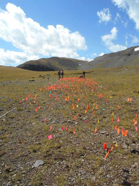
Since 2002, meanwhile, Lawrence Todd of CSU has been documenting sites and artifacts in the Absaroka Mountains, north of the Wind River Range. Wildfires from 2006 through 2011 revealed many new sites and artifacts. For example, after the Little Venus Fire of July and August 2006, Todd and his teams recorded about 1,600 percent more surface artifacts in the area. They also found a greater diversity of objects: ceramics, metal, glass beads, pieces of obsidian and faunal remains, like animal bones.
After the 2011 Norton Point Fire north of Dubois, Todd and his team coded more than 17,000 pieces of chipped stone in one 1,052-acre area. When ancient people made projectile points or other stone tools, they also left hundreds or thousands of stone chips behind, as well as the finished artifacts. Todd estimates that these pieces represent less than half the materials exposed by that fire in their survey area.
High-altitude subsistence
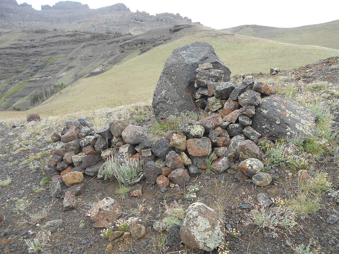
Intense summer heat, which often dries out the lower elevations in Wyoming by midsummer and causes wildlife to seek cooler, moister environments, also drove game of long ago high into the grass-rich mountain habitat. Ancient hunters almost certainly followed, as shown by drive lines and corrals for herding mountain sheep, plus stone blinds and other evidence of large-mammal harvesting found decades ago in high elevations. But the artifacts tell only part of the story.
Most or all the villages in the Wind River Mountains are near stands of whitebark pine trees, whose abundant, nutritious nuts may have been a staple for the people who lived there. Adams and his associate, Rhoda M. Schantz, have calculated that 10 kilograms of unshelled pine nuts, about 3,000 cones’ worth, is the meat equivalent of a large pronghorn antelope. Other likely plant foods were the biscuitroot, the sego lily bulb and yampah root. The presence of metates and manos—a mortar/pestle set of tools—also suggest the processing of various plant foods.
Site and artifact ages
Radiocarbon dates from High Rise Village range from about 4,500 years before the present (BP) to about 150 years ago—around the time the Union Pacific Railroad was built across Wyoming. The older dates might not reflect human occupation, because these dates correspond to the age of nearby stands of whitebark pine, which later occupants may have burned for firewood. The likelier High Rise dates are 2,800 to 150 BP, placing these sites and artifacts in the archaeological periods known as the Late Plains Archaic through the mid-1800s. However, some items suggest humans lived in the area much earlier. Todd and Tory Taylor have both found Folsom-era projectile points dating from approximately 10,000 or 10,500 years BP at high altitudes.
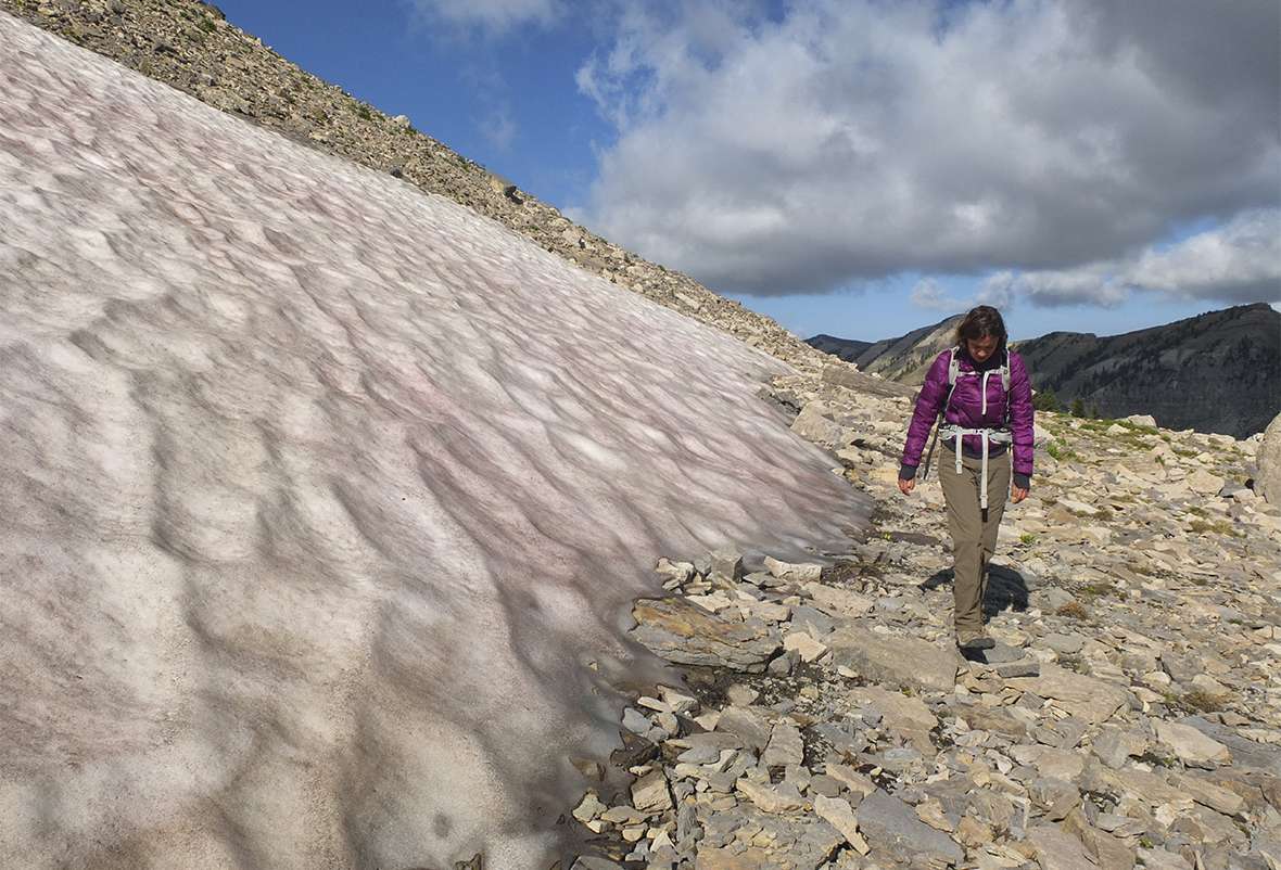
Ice-patch archaeology
“Because of global warming, high alpine ice is melting at an unprecedented rate,” writes Stirn. “[A]s a result, [it] is exposing cultural and biological material that has been encased and preserved for thousands or even tens of thousands of years.”
Less than one percent of all artifacts found in Wyoming have been found because of melting ice. However, these artifacts are often so well preserved that archaeologists can sometimes learn more from a single ice-patch artifact than from one discovered elsewhere.
“[M]ost tools used by past cultures were probably made of organic material,” Stirn notes, “and haven’t survived over the years. So, when we do find an ice-patch artifact it is especially exciting because it provides a rare glimpse into the past that we don’t normally get to witness.” Stirn explains that this is one reason archaeologists “are particularly alarmed at the extent that ice in Wyoming is disappearing, along with the fragile archaeological information preserved within.”
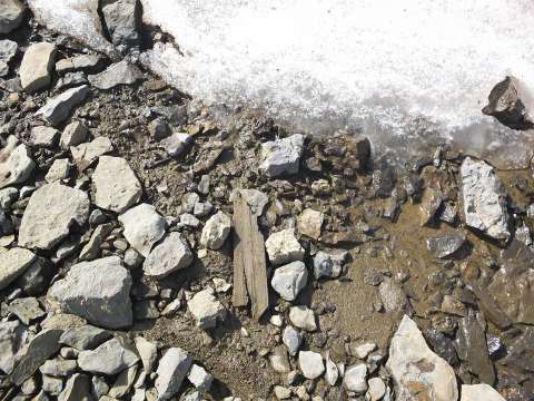
For the past four years, Stirn and Rebecca Sgouros, director of community archaeology for the Jackson Hole Archaeology Initiative, have been exploring ice patches in the Grand Tetons as part of the Teton Archaeological Project. In field season 2014, they found a stave-cut segment of whitebark pine, radiocarbon dated to approximately 2,700 BP, shown in the second photo in this article. A stave-cut piece of wood is cut out of a tree along the grain.
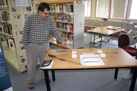
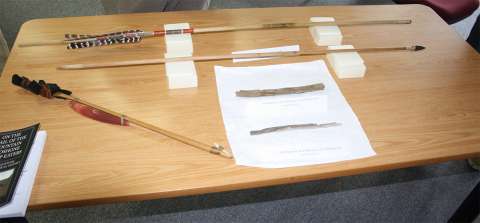
Dr. Craig M. Lee, of the Institute of Arctic and Alpine Research (INSTAAR) at the University of Colorado in Boulder, has been studying ice patches in the Greater Yellowstone Area for more than a decade. The Greater Yellowstone Area, about 24,000 square miles, includes Yellowstone National Park and five national forests surrounding it, Grand Teton National Park, most of the country along Idaho’s eastern border and the mountainous south-central portion of a small part of southern Montana, including the Gallatin and Absaroka mountain ranges.
Lee has documented about 25 organic artifacts, including wooden shafts and shaft fragments and one object of plaited leather and bark. An atlatl dart, about 10,300 years old, which Lee found in Wyoming, is the oldest known ice-patch artifact in the world. Atlatls were ancient dart-throwing devices used to kill game.
High-altitude environments “were totally and completely populated,” Lee notes, “and ice-patch recoveries help to back up, and to overcome our ignorance of, tribal oral histories about how the ancestors of today’s Native Americans lived up high.”
Through the Greybull River project in the Absaroka Range, Todd began researching ice patches in 2014. Beginning in 2015, Todd’s group studied 11 ice patches identified earlier by Lee, who used a computer model to predict locations likely to contain ancient perishable artifacts.
Todd and his team found thousands of items. These include two wooden bows and nearly 20,000 pieces of chipped stone in an area of about 430 acres. At about 10,350 feet elevation, they found the highest stone circle habitation sites in the GYA. In 2015 and 2016, Todd’s team found 7,000 pieces of chipped stone in an approximately 3 percent sample of the surface of one site that lies between 9,600 and 10,500 feet.
The occupants
 Shoshone probably lived in the Absarokas and at High Rise Village and similar sites in the Wind River Mountains. Artifacts found at High Rise Village and associated with the mountain Shoshone include steatite bowls, which women used and passed down to their daughters. Another tool associated with women is the teshoa, made of stone and used as a knife and also for harvesting roots and other digging. Early white explorers observing the Shoshone noticed only women using the teshoa, but archaeologists don’t know whether it was actually a tool used exclusively by women.
Projectile points associated with the Shoshone and found at High Rise Village are of the desert tri-notch, cottonwood triangular and rose-spring style. Archaeologists have also found steatite pipes, beads and atlatl weights at other locations in Wyoming.
“None of those artifacts by themselves necessarily indicates Shoshone,” writes Stirn, “but if they are all found at one site we can be a little more certain.”
The ancient mountain Shoshone are probably the ancestors of the small groups of Shoshone who lived in the mountains of northwest Wyoming and who, in more recent times, became known as the Sheepeaters.
More modern migration
Ancestors of modern-day Northern Paiute, Ute and Shoshone are referred to as Numic speakers. Archaeologists generally hypothesize that some Numic speakers occupied, or at least migrated through, the Great Basin—the area encompassing most of Nevada and approximately the western half of Utah, plus small portions of southwest Wyoming, southeast Idaho, southeast Oregon and California east of the Sierras.
In the late 1970s and early 1980s, discoveries of alpine villages in the Alta Toquima Range in Nevada and the White Mountains of California generated the hypothesis that these peoples migrated from west to east. Artifacts and sites in these locations date from approximately 2,500 BP or younger.
The earlier dates of artifacts in the Absarokas, and also High Rise Village, however, suggest that human occupation in high-altitude Wyoming may have predated occupation of the California and Nevada villages. This in turn could imply that Numic speakers actually migrated east to west, but more research is needed to corroborate this hypothesis.
Tough logistics—and new questions
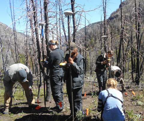
Most high-altitude archaeological exploration in Wyoming occurs in wilderness areas or national parks. A week-long expedition is a backpack trip, sometimes or often including backcountry outfitters and pack animals. Many archaeologists take notes using only minimal technology. Some prefer paper and pencil to laptop computers, batteries and other digital equipment that must be hauled along and protected from harsh weather or falls from steep slopes. Most use digital cameras and GPS units.
At the same time, though many sites are difficult to reach and removing artifacts from public land is a crime, recreational looting of the areas continues to be a problem.
Until these recent discoveries, most archaeologists believed ancient peoples lived in lowlands, except when forced into higher elevations by extreme conditions such as population pressure, scanty hunting or famine. The mountain villages, sites and artifacts found by Adams, Stirn, Sgouros, Todd, Lee and their teams strongly suggest that earlier hypotheses are incorrect, however. The scope of these ongoing projects is likely much more far-reaching than previously realized, and scientists continue to search for more evidence to support and augment current theories.
[Editor’s Note: Those interested in learning more about the state’s archaeological finds and methods can learn more during Wyoming Archaeology Awareness Month, celebrated each September. A different archaeological site is featured each year, with a commemorative poster highlighting the location, and a variety of other activities occur to help promote the state’s archaeological advancements. For more information, visit the Wyoming State Historic Preservation Office Archaeology Awareness Month website at http://wyoshpo.state.wy.us/aamonth/.]
Resources
Primary Sources
- Adams, Richard. Adjunct Instructor, Archaeology, Colorado State University, Fort Collins, Colo. Emails to author, Feb. 19, 2018; March 18, 21, 2018.
- Lee, Craig, M. Institute of Arctic and Alpine Research (INSTAAR). University of Colorado, Boulder. Emails to author, March 16, 21, 2018.
- __________. Telephone interview with author, March 20, 2018.
- Stirn, Matthew. Director of Archaeological Research, Jackson Hole Historical Society and Museum, Jackson Hole, Wyo. Emails to author, March 9, 12, 13, 19, April 15, 2018.
- Todd, Lawrence C. Colorado State University Professor Emeritus of Anthropology, Fort Collins, Colo.Emails to author, March 19-21, 2018.
Secondary Sources
- Adams, Richard. “Archaeology with Altitude: Late Prehistoric Settlement and Subsistence in the Northern Wind River Range, Wyoming.” Ph.D. diss., University of Wyoming, 2010. Accessed Jan. 31, 2018, via www.proquest.com.
- Adams, Richard, Tory N. Taylor, Meredith E. Taylor, John B. Lund, Byron A. Schroeder, Orrin Koenig and Matthew A. Stirn. “Untrammeled by Man: Wilderness Archaeology in Wyoming.” The SAA Archaeological Record14, no. 2 (March 2014): 11-14. Accessed Jan. 20, 2018, at http://onlinedigeditions.com/publication/?i=201212
- Adams, Richard and Connor Johnen. “Revisiting 1969: Retracing an Early CSU Archaeological Survey of the Wind River Range, Wyoming.” Colorado State University: The Department of Anthropology and Geography. Accessed Feb. 14, 2018, at https://anthropology.colostate.edu/2015/10/wind-river-range-wyoming/.
- Anderson, Richard. “Fish stew, delving into the past at high camp: New tests, techniques offer details about ancient people’s lives in the Tetons.” Jackson Hole News & Guide. Nov. 25, 2015. Accessed Jan. 30, 2018, at http://www.jhnewsandguide.com/news/features/fish-stew-delving-into-the-past-at-high-camp/article_4ad98ff7-b47a-51a1-b064-36a62275d050.html.
- DePastino, Blake. “13 Ancient Villages Discovered in Wyoming Mountains May Redraw Map of Tribal Migrations.” Accessed Jan. 29, 2018, at http://westerndigs.org/thirteen-prehistoric-villages-discovered-in-wyoming-mountains-may-redraw-map-of-tribal-migrations/.
- ———. “Wyoming Wildfire Reveals ‘Massive’ Shoshone Camp, Thousands of Artifacts.” Accessed March 12, 2018, at http://westerndigs.org/wyoming-wildfire-reveals-massive-pre-contact-shoshone-camp-thousands-of-artifacts/.
- Dominick, David. “The Sheepeaters.” Annals of Wyoming 36, no. 2 (October 1964): 131-168. Accessed Feb. 20, 2018, at www.archive.org/details/annalsofwyom36121964wyom.
- Hughes, Susan S. “The Sheepeater Myth of Northwestern Wyoming.” Plains Anthropologist 45, no. 17 (February 2000): 63-83.
- Kornfeld, Marcel, George C. Frison and Mary Lou Larson. Prehistoric Hunter-Gatherers of the High Plains and Rockies. 3d. ed. Walnut Creek, Calif.: Left Coast Press, Inc., 2010.
- Lee, Craig M., with contributions by Robert L. Kelly, Marcia Peterson, Matt Stirn, Rachel Reckin, Rebecca Sgouros and Lawrence C. Todd. “Frozen in Time: What Once Was Lost, Now is Found.” Flyer and poster for Wyoming Archaeology Awareness Month, Sept. 2018. Accessed April 10, 2018 at http://wyoshpo.state.wy.us/AAmonth/Index.aspx.
- Lee, Craig M. and Kathryn Puseman. “Ice Patch Hunting in the Greater Yellowstone Area, Rocky Mountains, USA: Wood Shafts, Chipped Stone Projectile Points, and Bighorn Sheep (Ovis Canadensis).”American Antiquity82, no. 2 (2017): 223-243. Accessed March 15, 2018, at https://www.cambridge.org/core/services/aop-cambridge-core/content/view/5C2F5BADBFA1228081EC9C40E7B6F43B/S0002731616000329a.pdf/ice_patch_hunting_in_the_greater_yellowstone_area_rocky_mountains_usa_wood_shafts_chipped_stone_projectile_points_and_bighorn_sheep_ovis_canadensis.pdf.
- Lee, Craig M. “Withering Snow and Ice in the Mid-latitudes: A New Archaeological and Paleobiological Record for the Rocky Mountain Region.” Arctic 65, Suppl. 1 (2012): 165-177.
- Morgan, Christopher, Ashley Losey and Richard Adams. “High-Altitude Hunter-Gatherer Residential Occupations in Wyoming’s Wind River Range.” North American Archaeologist 33, no. 1 (2012): 35-79. Accessed Feb. 1, 2018, at https://www.unr.edu/Documents/liberal-arts/anthropology/cmorgan/Morgan_et_al_2012-High_Rise_Village.pdf.
- Schroeder, Byron. “How Much Difference is in a Thousand Meters? The Inconvenience of High Altitude on Local Residential Patterns.” The SAA Archaeological Record14, no. 2 (March 2014): 36-40. Accessed Jan. 20, 2018, at http://onlinedigeditions.com/publication/?i=201212.
- Sgouros, Rebecca and Matthew A. Stirn. “An Ice Patch Artifact and Paleobiological Specimen from the Teton Mountains, Wyoming, USA.” Journal of Glacial Archaeology 2, no.1 (2015): 3-24. Accessed Feb. 22, 2018, at https://www.researchgate.net/publication/305185867_An_Ice_Patch_Artifact_and_Paleobiological_Specimen_from_the_Teton_Mountains_Wyoming_USA.
- Stirn, Matthew. “Modeling site location patterns amongst late-prehistoric villages in the Wind River Range, Wyoming.” Journal of Archaeological Science 41 (2014): 523-532. Accessed Jan. 26, 2018, at https://www.researchgate.net/publication/262068198_Modeling_site_location_patterns_amongst_late-prehistoric_villages_in_the_Wind_River_Range_Wyoming.
- Stirn, Matthew A. “Why All the Way Up There? Mountain and High-Altitude Archaeology.” The SAA Archaeological Record14, no. 2 (March 2014): 7-10. Accessed Jan. 20, 2018, at http://onlinedigeditions.com/publication/?i=201212.
- Stirn, Matt. “Do You Love Camping in the Mountains? So Did People 11,000 Years Ago.” Oct. 19, 2016. nationalgeographic.com. Accessed Dec. 30, 2017, at https://www.nationalgeographic.com/adventure/destinations/united-states/wyoming/Alpine-archaeology-reveals-ancient-mountain-villages/.
- Todd, Lawrence. “A Record of Overwhelming Complexity: High Elevation Archaeology in Northwestern Wyoming.” Plains Anthropologist (Memoir 43) 60, no. 236: 67-86.
- Todd, Lawrence, Rachel Reckin, Emily Brush, Robert Kelly and William Dooley. “An Alpine Archaeological Landscape in the Greater Yellowstone Ecosystem, Wyoming.” Accessed March 19, 2018, at http://www.grsle.org/Conferences/Todd_etAl_SAA_2017.pdf.
- Todd, Lawrence, Emily Brush and Kyle Wright. “Forty Days in the Wilderness: 2015 Park County Historic Preservation Commission Archaeological Inventory and Assessment on the Shoshone National Forest, Wyoming. Accessed March 19, 2018, at http://www.grsle.org/Fieldwork/ToddEtAlPlains_2015.pdf.
- Todd, Lawrence, Rachel Reckin, Emily Brush and William Dooley. “Migration Corridors, Ice Patches, and High Elevation Landscapes.” Accessed March 19, 2018, at http://www.grsle.org/Conferences/Todd_et_al_2016_Elk&Ice.pdf.
- United States Department of Agriculture. National Forest Service, Intermountain Region, Ogden, Utah. “Archaeological Reconnaissance Survey of the Bridger-Teton National Forest.” George C. Frison. Report no. 1. January 1975.
- Young, Chris, Tory Taylor and Richard Adams. “A Folsom Point Fragment from 3300 m.a.s.l. in the Wind River Range, Fremont County, Wyoming.” Current Research in the Pleistocene 25 (2008): 128-129.
Illustrations
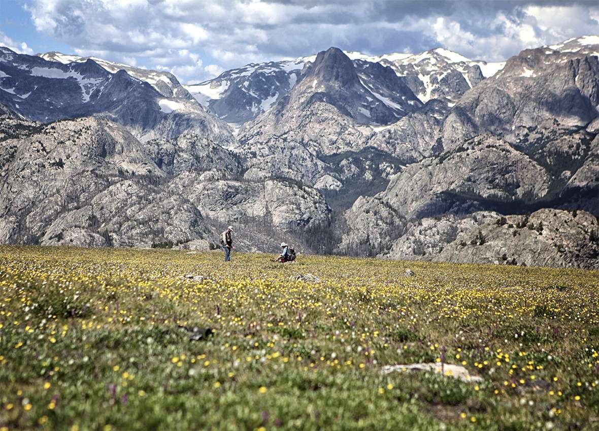
- The photos of the archeologist walking the edge of the ice patch, the artifact at the edge of the patch and the two men in the meadow are by Matt Stirn. The photos of the game blind and the two photos of crews with satellite receivers are by Larry Todd. The photos of Craig Lee and his artifacts, taken when he was visiting with students at Wyoming Indian High School in Ethete, Wyo., are by Tom Rea. Used with permission and thanks.