“The Roughest Mountains & Deepest Cañons:” William Richards and the Boundary Survey of 1874
William A. Richards is fairly well known as an 1890s governor of Wyoming who went on to national office in the U.S. Department of the Interior. Less well known is his background as a surveyor who had a way with words. His diary, excerpted below, gives a you-are-there view of the rugged western boundary of Wyoming Territory and the challenges he and his party overcame when surveying it.
Born in Wisconsin to pioneer parents, Will set out at age 20 for Omaha, Neb., in 1869. He hoped to find work with the Union Pacific Railroad, which was striving to finish the transcontinental line, but he and hundreds like him had no luck in its shops or anywhere else. Finally Richards found an entry-level position with a surveying party. Remaining in Omaha, he obtained surveying contracts of his own, and also worked for newspapers and studied law.
In 1873 he helped his elder brother, Alonzo, survey the southern boundary of Wyoming Territory. (The eastern boundary had been surveyed in 1869, soon after the territory had been created.) The western boundary would run through rougher country, but Alonzo entrusted most of that survey to Will the following year. The young man passed the test and married Harriet Alice Hunt that December.
Over the next decade he continued surveying. Though elected a county surveyor in California and then Colorado, where he also served as city engineer of Colorado Springs, he wanted more for his wife and two daughters than what he called a “hand to mouth” existence. After other ventures failed, in 1885 he risked homesteading in Wyoming Territory’s Bighorn Basin, which had some of the last unclaimed grassland in the west.
The Richards family loved their ranch on the No Wood River south of Ten Sleep, Wyo. But the lack of church and schools led him to apply for U.S. surveyor general of Wyoming Territory in 1889 so they could live in Cheyenne. In this position he would award contracts for surveys of government land and ensure their accuracy.
Richards was elected governor on Nov. 6, 1894, and was inaugurated on Jan. 7, 1895. With State Engineer Elwood Mead he campaigned for better management of public lands in hopes of saving the grasslands and forests and developing irrigated agriculture. Richards used his knowledge of the land laws to acquire badly needed federal acreage for the state.
His experience as surveyor general and as governor helped him get appointed assistant commissioner of the U.S. General Land Office at the end of his term. The GLO had charge of the millions of acres of public lands—one third of the country—that could be claimed by homesteaders and others.
Appointed commissioner by President Theodore Roosevelt, Richards assumed office on Feb. 2, 1903. Richards took measures to protect native ruins from looting, and helped spur the passage of the Antiquities Act in 1906. Wyoming’s Devils Tower would be the first National Monument declared under the Act.
Ill health helped him realize that eight years in the land office was enough, and he retired to his ranch in March 1907.
Tackling Wyoming's western boundary
In May 1874 the Richards brothers outfitted their survey in Evanston, Wyoming Territory; it was the last real town William would see until August. About a third of the way north up the territory’s western border, Alonzo turned the job over to Will, but would return to finish it.
The party met a trapper and his American Indian wife on June 25. The man “gave rather a discouraging account of the country before us, more especially of the rivers,” Will wrote. And “heavy fallen timber— Well, that’s where our line goes and where we’ll go or ‘bust.’” On the 26th, “Mosquitoes worse than I ever saw them before, but the nights are too cold for them to be about.” Water froze in their camp.
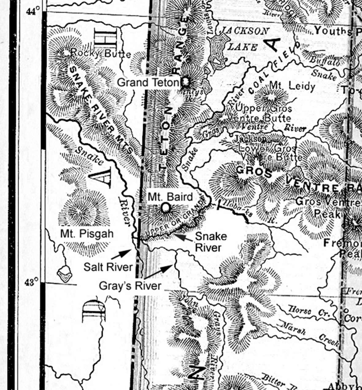
Crossing the Snake River
Three rivers—the Salt, Gray’s and Snake—flow into one valley near present Alpine, Wyo., south of Jackson. After crossing the Salt, the “dreaded Snake” looming ahead made them decline an invitation to a dance at a mining camp. On July 4 Will wrote,
“July 4. The mental barometer of this outfit for today shows the greatest change of the trip— We were at work early, stimulated for hard work with a good strong breakfast of baked beans, bread, bacon, trout, coffee & dried apples— No one seemed to feel very enthusiastic either on the subject of our national Independence or what was of more moment, the success of our raft—
“We launched her safely, she floated like a duck, but then two men boarded her with poles, and their best efforts failed to get it 50 feet from shore. As this was the narrowest point we could find, and it was 450 feet wide there— We knew that rafting was a failure. We had thought of building a large one that would take our whole outfit at once, . . . We might have done this, but could not cross our stock that way. It would have been risking everything on a single chance, and I determined to only try it as a last resort. When the uncertainty was past, relative to the small raft, every man seemed relieved, and the Barometer rose slightly— We went in to dinner in a light rain, no nearer across the River than when we first reached it— If we had failed, Ben, our cook, had not, and we had a dinner good enough for any 4th of July, the main features of which different from our usual fare, were corn bread, dried plum sauce & trout, the last however we now have at every meal, as they are very plenty in the Snake, large and easily caught. —
“After dinner, as it still rained, we had a first rate game of casino. . . but I will own that my jollity was a little forced, and of a melancholy nature—and nothing but force of will kept me from not exactly being ‘blue’ but thinking of [family], and wishing that I was with them, and the Western Bdry. in Helena—”
On a search for a way across, fortune led them to a camp of trappers and prospectors, one of whom had once lost everything trying to cross the river. A joint effort could help them both: Will would provide the manpower and the prospector his knowledge of canoes.
“We returned to camp and related the story of our discovery, and the Barometer rose rapidly and it seemed a little like the Glorious 4th—
“We had thought of a canoe but none of us knew how to build or manage one, and at the best they are dangerous. It seems now that we would soon cross the old Snake—”
Work began the next day, and Will and another man went to Iowa Bar, a mining camp on the Idaho side of the border, to mail letters and get supplies.
“We got caught in a thunder storm when about half way— and got wet through— Reached the camp at sundown, hungry, wet and tired— The distance is 17 miles, 14 being up the Caribou creek which we crossed 13 times— got a good supper at a so-called restaurant . . . But as we didn’t like the looks of some of the loafers around the camp, and thinking they might be in need of a mule, we came into the timber on the mountain, picketed our mules, built a camp fire, and for two hours have been drying our blankets & clothes— and I am writing with my pants & drawers hanging from a limb before the fire—
“July 6. Arose at sunrise a little stiff. We slept one on each side of the fire and while we kept it going we were warm and slept, but not very good. Went in to town to breakfast.”
At Iowa Bar there were about a dozen log houses and five saloons, and “so many Bars that I could not distinguish the ‘Iowa.’”
“Quite a ‘big time’ was had there the 4th— A lot of Mormon women, or ‘Irrigators’ as they are called, came in from Soda Springs [Idaho Territory] 50 miles distant & on the evening of the 3rd they had a dance at Iowa Bar, on the 4th went over to the other camp, 7 miles, on the head of Caribou creek & had another dance, on the evening of the 5th. Sunday had another one at another camp, getting up at 12 M. to commence, so they reported— the evening of the 6th they were to dance at Waumuck’s camp & on the 7th at Soda again. For one set of ladies that is doing pretty good dancing—. . . Went to camp at sundown in a heavy rain. Mush & Molasses (made from sugar) for supper.
“July 7. A very heavy rain last night. The river this morning a good deal higher & very muddy showing a big rain above— . . . I saw an old gray-headed miner at the camp who came west in ’49. He is now broke & intends selling his horses, taking the money and going home— a broken down discouraged old man. The mines & the greed for gold have made his life a failure— I learned after seeing him, learned from others, that he started from Hazel Green [Wisconsin] in ’49 & doubtless Father knew him.”
Crossing with a single canoe failed. But “[b]y splicing two together we have quite a good boat which can be rowed.” The river also fell, and on July 9 they succeeded.
“Hurrah! . . . It was hard work for us, for the current raged fearfully, but we kept at it till all was over— . . . Twelve round trips were made— . . .[Getting the animals across was a challenge and] quite an exciting time for me, for if they failed to make it there was a chance to lose money pretty fast on mules, besides the delay of the work. . . .We were seven days in getting across but did it well & safely without losing any thing at all—"
Into the mountains
“July 10. . . . Fourteen hours without eating, & climbing the worst kind of mountains, inclines one to relish his supper, & bean soup, ham, coffee & bread melted before our appetites like dew before the sun.
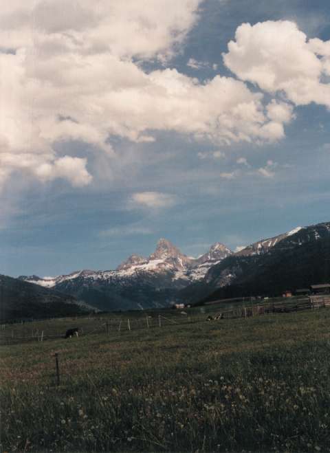
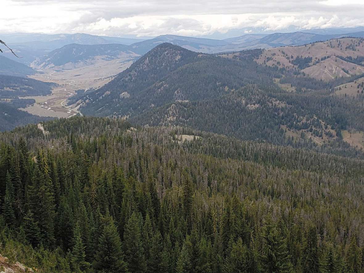
“July 11. The S. Slope of the Mountain is impassable for the chain men, so we ran a base line west from [a particular point] 34 chains [about 750 yards] & sent Dick with two men to the top of the mountain to get the line up and we will triangulate the distance. [That is, knowing the length of one side of a triangle and the size of the angles at the two ends of that one side, it’s possible to calculate the distance to the third point.] We can not get a sight on the highest peak because of an intervening peak covered with timber. [He and another man went hunting, no luck.] . . . Camp at the Western foot of the big mountain. . . . I think it will be the highest point we will reach on this line— Its elevation as near as we can take it is 10300 ft. From it we have a magnificent view upon all sides. Looking back we can see the Salt River valley for 30 miles hemmed in on the east with the Salt River Mts. which are rough, snow clad & many of them higher than this point. On the west of it are foot hills gradually rising till they terminate in the Caribou Mts., . . . . To the N. W. we can see Snake River winding through the mountains [in Idaho Territory] for about 10 miles then the bottom through which it runs gradually widens out in a prairie bottom & the hills skirting it become lower, while away in the distance, showing dimly like a fog cloud, is another range of high mountains at least 125 miles away— coming around to the east the view is limited to a few miles by the Snake River mountains of which this mountain [The Bass & Mosiah], is one. . . . we see the Tetons looming up— the largest is Mt. Hayden [Grand Teton]. . . . It is the grandest looking Peak we have yet seen and towers far above all its fellows. . . . To the East & N East of it we can see the lower country of the Yellowstone. To the East of us, a little north, we see a peak which we think is Mt. Baird—
“Taken altogether the view from ‘The Bass’ fills my idea of mountain scenery. . . . Total ascent today 4100.” This mountain has been variously named Mt. Richards, The Bass & Mosiah or just “The Bass.” However, The Bass has no official name, according to the Idaho State Geological Survey office. It is known as Mt. Richards on a mountain climbers’ website. At 9,600 feet, its elevation is lower than Richards’s estimate.
“July 13. “The weather is beautiful, though more like September than July— . . . 11:30 P. M.—‘Lying out’ by a camp fire supperless & without blankets or coats . . . A thunder storm had also come up, and as we were at an elevation of 10300 ft. we got the full benefit of it. We took shelter under a big rock and ate our dinners during the storm. We had no crockery or it would have been dropped & broken sure. The flashes of lightning followed each other in such quick succession, that there was almost a constant roar of thunder. We were surrounded by cañons from 2000 to 3000 feet deep, and the thunder roared & echoed & reached through them in a manner that was grand in the extreme, but as the lightning was playing around us, in such close proximity that our hair stood on end (but whether from electricity or fear I will not say) it had few charms for us. We could see the lightning below us, but the rain was certainly above us. Several trees were struck on our mountain and we half expected to see the lightning from the cañon attempt to climb a tree—
“When we left ‘The Bass’ it was 3:45 P.M. . . . we were overtaken by another storm which delayed us another hour. Dick & Tom went ahead . . . to another divide, had three large trees to chop out, so that it was 7 P.M. when we started for camp. . . with no idea as to where it was, except that it was on the creek to the west of us, and the roughest mountains & deepest cañons intervening that I ever saw. We took down a cañon, walking over fallen trees & large boulders & through underbrush shoulder high, wet from the rain. . . . [We] kept going until 11 P.M. when the cañon became so narrow & so filled with fallen timber that we could not travel with safety any longer, as I had the transit and Wheaton the chronometer— . . . so we stopped to camp, as it was raining a little it was almost impossible to build a fire, the only timber we could find in the dark being partly green fir—
“While hunting a dry pine log we. . . found the five other men . . . with a good fire and quite comfortably fixed. . . . We have wrung out our clothes, put them on again and are now sitting around the fire the hungriest, tiredest, wetest [sic] but jolliest eight men that ever lay out on the mountains. Not a cross word has been said nor a complaining one— . . . The rain has ceased, our fire keeps us warm, and we will pass a comfortable night though we won’t sleep much.
“July 16. Our camp men decided yesterday that it was impossible to take our pack train any further up this cañon, which is our only way of keeping near the line. I told them we would go up the cañon anyway, so this morning left camp at 6 A.M. with every man but the cook, to make a way. We moved immense boulders, cut down trees, graded hill sides, and made crossings on the stream with such good success that at 9 A.M. sent the men back to bring up the camp. . . .
“We’re delayed by an accident to one of the mules (Dandy Pat) who tipped over backwards off a cliff forty feet high, made two complete revolutions lengthwise, and landed square on his back in the stream. Alighting upon the pack was all that saved his life, for it broke the force of the fall, also broke our large Dutch oven, busted a seamless sack containing sugar & 50 lbs. washed away, and smashed the pack saddle all to pieces. . . . If our provisions hold out we will be all right. Hope to find game soon. Saw a great many fresh signs today of Elk, deer, bear & mountain lion. The boys saw two bear near camp.”
They spent another week in rough terrain. By the 25th the country grew kinder except to the mules, which were so tormented by horseflies that smoky fires had to be lit for protection. With gentler terrain and less timber, they were able to make better time—for the moment.
“Sunday, July 26. “No work today, as this is a good camping place. Spent the day in washing, mending, hunting, fishing & resting. [When hunting in the mountains,] got caught by the night on a side hill so thickly covered with fallen timber that we could not lead our horses through it nor could we follow our trail out in the darkness, so we were compelled to leave them there and go to camp on foot—three miles, got in at 11 P.M. . . .
“July 27. Breakfast with trout & antelope at 6 a.m. . . . Took until 10:30 to get the timber chopped out of the Teton River bottom. Left the prairie . . . and entered a gently rolling country with scattering timber and numerous streams, making very good running. . . . Weather splendid. . . . The boys got the ponies out of the timber by cutting a road for them.
“Aug. 1. . . . This is the third morning in succession that we have had wet clothes to put on to start with, and it is getting slightly monotonous not to say unpleasant, with the thermometer almost down to freezing, to put on wet pants, drawers, stockings & shoes.”
Such unpleasantness would not keep them from working, but the weather often interfered with astronomical readings. The western boundary was to fall on a certain degree of longitude. Longitude was determined by time, which was why they were carrying a chronometer. Those results could then be checked against precise measurements of the movement of stars.
“Aug. 10. Clouded up last night so that we could get no time stars … [26° F at sunrise. They made 2.45 miles before it began to rain at 11 a.m.] We built a bivouac with a big fire before it and ate our dinner. The rain soon changed to snow which melted almost as fast as it fell. We stood it about an hour then started back 2-1/2 miles to camp which we reached at 1 P.M. wet through and a little cold. I had told the camp men not to move from that camp if it stormed before noon, as we would rather walk back to a dry camp than to pitch our tents on wet ground in a storm, though nearer the line. It snowed hard nearly all the afternoon, the mules huddled together in the timber and we sat in the tents with our overcoats on. About five o’clock the storm subsided, leaving the ground covered with two inches of snow . . . we went to bed warm & dry, thankful that we fared no worse.
“Aug. 11. . . . we have enough provisions to last us till Sept. 1st of everything but meat. We hope to find game on the Madison [River] but have been disappointed in the game in this country, or rather not in it.”
On Aug. 26, Will met Alonzo and eminent astronomer Augustus MacConnel in Bozeman, Montana Territory. They trekked back to the Corner to confirm the astronomical calculations and set the monument for the northern terminus, 277.9 miles from the southwest corner. The only stone available was so hard that “our tools made expressly for the purpose would hardly make an impression upon them,” Alonzo wrote. The log used for the monument was still standing when other surveyors visited in 1958, and the stadia rods the Richardses left behind were nearby, minus their spirit levels.
Other surveyors took on the northern boundary; it was done in segments, had to be resurveyed, and was not completed until 1882. The surveys of the southern and western boundaries were later found to be accurate.
The full 1874 diary is one of four in the recently published William A. Richards – Diaries of a Frontier Surveyor. Included are his adventures as a fledgling surveyor in Nebraska in 1869, the 1873 survey of Wyoming's southern boundary and his exploration and settlement of the Bighorn Basin in 1884-85, along with supplemental articles and illustrations. More about the book and Richards himself is available on WilliamARichards.com.
Resources
Primary Sources
- Cheyenne Daily Leader, Jan. 8, 1895, accessed Dec. 4, 2020 at newspapers.wyo.gov.
- Cheyenne Daily Sun, Nov. 7, 1894, and accessed Dec. 4, 2020 at newspapers.wyo.gov.
- Colorado Springs Weekly Gazette, April 19 and May 24, 1884. Colorado Historical Society.
- Department of the Interior, General Land Office. Annual Report of the Commissioner of the General Land Office to the Secretary of the Interior for the Fiscal Year Ended June 30, 1904. William A. Richards. Washington, D.C.: GPO, 1904. 58-60.
- ______________________________________Annual Report of the Commissioner of the General Land Office to the Secretary of the Interior for the Fiscal Year Ended June 30, 1905. William A. Richards. Washington, D.C.: GPO, 1905. 40.
- ______________________________________ Annual Report of the Commissioner of the General Land Office to the Secretary of the Interior for the Fiscal Year Ended June 30, 1906. William A. Richards. Washington, D.C.: GPO, 1906. 47-48.
- _______________________________________Circular Relating to Historic and Prehistoric Ruins of the Southwest and their Preservation. Edgar L. Hewett. Washington, D.C.: GPO, 1904.
- “Diary Kept by W.A. Richards in Summer of 1873: Survey of South Boundary of Wyoming.” Annals of Wyoming 7, nos. 4 and 5 (April and July 1931): 467-482, 492-595.
- Mead, Elwood. Second Biennial Report of the State Engineer to the Governor of Wyoming. 1893 and 1894. Cheyenne, Wyo.: The S. A. Bristol Company, Printers and Bookbinders (1894), 22-32.
- ___________. Third Biennial Report of the State Engineer to the Governor of Wyoming. 1895 and 1896. Cheyenne, Wyo.: The S. A. Bristol Company, Printers and Bookbinders (1897), 13-35, 139-145.
- ___________. Fourth Biennial Report of the State Engineer to the Governor of Wyoming. 1896 and 1897. Cheyenne, Wyo.: The S. A. Bristol Company, Printers and Bookbinders (1898), 123-156.
- Message of William A. Richards, Governor of Wyoming, to the Third Legislative Assembly. 1895. Cheyenne, Wyo.: Cheyenne Sun, Printers and Bookbinders (1895), 13, 27-28, 29-36.
- Message of William A. Richards, Governor of Wyoming, to the Fourth State Legislature. 1897. Cheyenne, Wyo.: The S. A. Bristol Company, Printers and Bookbinders (1897), 19-21, 22-34.
- National Archives. Documents for the appointment of William A. Richards as assistant commissioner and commissioner of the General Land Office, RG 48.
- Retiring Message of Governor Wm. A. Richards to the Fifth Legislature of the State of Wyoming. 1899. Cheyenne, Wyo.: The S. A. Bristol Company, Printers and Bookbinders (1899), 12-16.
- Richards, Alonzo V. Field Notes of the Survey of the Western Boundary of Wyoming Territory. 1874. National Archives, RG 49.
- Richards, W.A. Diary, Jan. 1, 1879–Jan. 6, 1881. William A. Richards Family Papers, American Heritage Center, University of Wyoming, Laramie, Wyo.
- Richards, William A. Diaries, 1873, 1874, 1884-85. William A. Richards Collection, Wyoming State Archives, Cheyenne, Wyo. (Hereafter WSA)
- ________________. Diary, 1869-71. Nebraska State Historical Society, Lincoln, Neb.
- ________________. Letters and misc. papers 1870-1897. William A. Richards Collection, H82-61. WSA.
- Sullivan, Thomas Alan, comp. U.S. Department of the Interior, Proclamations and Orders Relating to the National Park Service Up to January 1, 1945, 171. “Setting aside Devils Tower National Monument, Wyoming, Proclamation 658.” (Sept. 24, 1906). Compiled 1947.
- “Surveying the Western Boundary of Wyoming: The Diary of William A. Richards, summer, 1874.” Annals of Wyoming 73, no. 4 (Autumn 2001): 2-19. Some introductory information in this article is incorrect.
- W. A. Richards to Edgar L. Hewett, Oct. 4, 1904. Quoted in Edgar L. Hewett, “Government Supervision of Historic and Prehistoric Ruins.” Science 20, no. 517 (1904 N.S.): 722-727. American Association for the Advancement of Science, Washington, D.C.
Secondary Sources
- Bland, Dennis B. “William A. Richards: Surveyor to Statesman.” Surveying and Land Information Systems 51, no. 4 (1991): 202-203. American Congress on Surveying and Mapping, Falls Church, Va. At the time of the article Mr. Bland was chief of the Office Operations and Review Section, Branch of Cadastral Survey, Bureau of Land Management, Cheyenne, Wyo.
- Douglas, John G. “Historic Preservation on the Public Domain: The Bureau of Land Management.” CRM Cultural Resource Management 22, no. 4 (1999): 24-26. U.S. Department of the Interior, National Park Service, Washington, D.C., accessed Sept. 14, 2000 at home1.nps.gov/CRMJournal/CRM/v22n4.pdf.
- Hill, Raymond E. “Position of the North-South State Boundary Between Montana and Wyoming.” Topographic Division Bulletin 9, no. 1 (June 1959): 34-37. U.S. Department of the Interior, U.S. Geological Survey, Washington, D.C.
- Lee, Ronald F. The Antiquities Act of 1906. U.S. Department of the Interior, National Park Service, Washington, D.C. 1970, accessed Sept. 10 2000 at www.nps.gov/archeology/pubs/lee_CH6.htm.
Illustrations
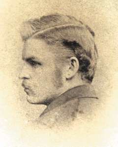
- The photo of Richards in 1874, the map and the photo of the Tetons are from the author’s collections. Used with permission and thanks.
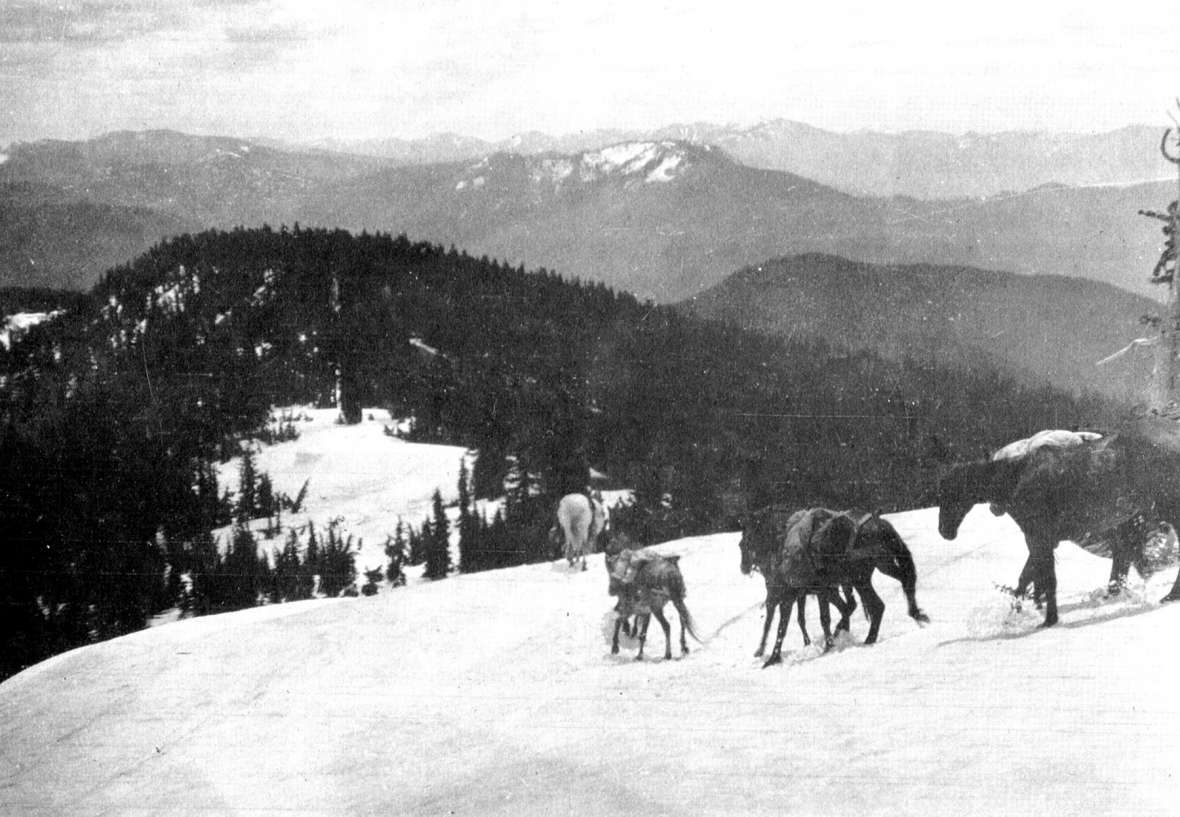
- The photo of the mules is from the Riverton Museum. Used with permission and thanks.
- The photo taken from the northwest corner of Wyoming is by Cody Schatz of Engineering Associates in Cody, Wyo. Used with permission and thanks.
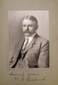
- The portrait of Richards as an older man is from the American Heritage Center at the University of Wyoming, from Box 2, Folder 7 in the William A. Richards Family Papers, Accession Number 00118. Used with permission and thanks.