Washakie County, Wyoming
Washakie County lies in Wyoming’s southern Bighorn Basin cupped by mountains: the Absarokas on the west, the Owl Creeks to the south and the Bighorns to the east. These mountains, however, are not included in the county, except for a small portion of the Bighorn Range. The terrain is comparatively flat. The main stream is the Bighorn River, flowing north to the Yellowstone. Significant tributaries within the county are the Nowood River, Nowater Creek, Gooseberry Creek and Fifteenmile Creek.
The elevation is approximately 4,000 feet, which allows a longer growing season for agriculture than is common in much of Wyoming. Little rain falls, however, so farming depends on irrigation. Native vegetation is grass and sagebrush on the plains and timber along the creeks and in the mountains.
Prehistory
The Colby Mammoth Site, located on private land close to the Bighorn River, was excavated by archaeologist George Frison in the 1970s. The site contained three Clovis projectile points and the remains of several mammoths that dated to approximately 11,000 years before the present. The Clovis people were among the earliest inhabitants of the region. Frison states that they lived in small wandering bands, making use of sand dunes and gullies to aid their hunts for the mammoths and bison that were their main food source.
Several American Indian tribes lived in the future Washakie County by the time European settlers reached it, including Arapaho, Shoshone, Crow and Cheyenne. Many of these bands moved into Wyoming from lands to the east as European settlement progressed in the 1700s and 1800s. Most of them claimed rights to winter in the valley of the Nowood River, a favorable place because of the shelter, timber and game there. Disputes over territory were common.
The fur trade
Several of the first explorers of what’s now Washakie County were trappers, but fur was never of great importance to the area's economy. In 1825, trapper William Ashley took his furs to market in bullboats made of buffalo hides stretched over light wooden frames on the north-flowing Bighorn River and along the Yellowstone, instead of following the more usual route by land down the Sweetwater and North Platte. Others followed his example, but water levels were highly unpredictable and the route down the Bighorn was never widely used. In 1829, employees of the Rocky Mountain Fur Company made one of the few serious attempts to trap beaver in the area, but they achieved nothing spectacular. By 1850, trapping in the area had all but ended.
Gold
In 1859, members of a U.S. Army expedition searching for routes between the Yellowstone and Missouri rivers to the north and the Oregon Trail to the south reported traces of gold in the streams of the Bighorn Basin. Longtime resident David Wasden wrote more than a century later that prospectors remained certain that immense discoveries were just ahead, but Indians interfered with such efforts and no major discoveries were made. The area was crossed, however, by the Bridger Trail, which led across the Owl Creek Mountains and along the Bighorn River toward Virginia City, Mont. Gold was discovered there in large quantities in the early 1860s. The route was named for mountain man Jim Bridger, but Chief Washakie, of the Eastern Shoshone tribe, supposedly showed him the way.
Chief Washakie
The county's name comes from Chief Washakie, whose tribe often wintered in the Bighorn Basin, especially after 1868 when a reservation was established for them on Wind River. After 1863, Washakie saw it in his band’s interest to remain at peace with the whites, and he was often called "the white man's friend" by the settlers and the U.S. Army.
In 1874 the tribe cooperated with U.S. Army troops under Capt. Alfred Bates on a raid against the Arapaho, traditional Shoshone enemies camped at the time on the headwaters of the Nowood River. The battle was the only major Indian-white conflict in the region that would become Washakie County.
Ranching
Cattle and sheep ranching both arrived in the future Washakie County around 1880. The first cattle rancher was Charles Carter from Oregon, soon followed by Henry Belknap and Otto Franc. Charlie "Dad" Worland brought in the first flock of sheep, but they died in the winter of 1886. Dave Dickie, who planned to settle in Canada with his sheep, homesteaded near the Owl Creek Mountains after cattlemen forbade him to pass the present-day site of Worland.
Beginning in the 1880s, flocks belonging to Lucy Morrison Moore, based on Copper Mountain, and to J.B. Okie, based at Lost Cabin, also grazed parts of what’s now Washakie County.
At first, cattle dominated, but by the mid 1890s, sheep outnumbered cattle. Until the early years of the 20th century, stockmen let their herds use the open range, turning the animals out year-round with little supervision and often allowing them to graze where they chose. This practice was common. Ranches operated from headquarters on small homestead parcels, near water, but the cattle roamed over thousands of acres of unclaimed land. Cattle ranchers worked together on roundups every spring to brand that year's calves, and again in the fall to divide the animals to be trailed to market from the ones that would winter over.
Various stories from early Territorial days tell of pioneers who abandoned failing cattle in the fall and returned to find the animals thriving in the spring. It's said that this inspired open-range ranching; in any case, the winters were mild enough for a time to allow it to work. The winter of 1886-87, however, was much more severe, and by then much of the territory had become badly overgrazed. Washakie County resident Ray Pendergraft, whose father endured that event, recalled in his 1972 county history:
The storms started early that winter, and by the 17th of November a high wind brought in a six-inch snowfall. . . . A second and more severe storm struck the entire country on December 8, bringing with it another 4 inches of snow and an icy wind. . . .The writer's father. . . .was building up his own cattleherd [sic]. The unprecedented fury of that winter cost him every hoof of cattle he had acquired, many froze to death standing and were drifted over with snow in that position. He got out of the cattle business much faster than he got into it.
Following this winter, many ranches throughout Wyoming Territory, including the Bighorn Basin, gradually changed to smaller operations with fewer cattle that might be fed native hay grown on the premises if necessary during the winter. Ranchers whose operations were too small, however, risked suspicion of cattle rustling. (Ranchers with large holdings were often suspected of rustling, too, but generally had more resources to deflect such accusations.)
Two small-operation ranchers in the area, Dab Burch and Jack Bedford, were arrested in 1892 by range detectives, and tied to their horses for the trip to Buffalo for trial. On the way, though, they were shot and killed by their captors. When murder charges were brought against the detectives two months later, they had disappeared.
Meanwhile, sheep ranching expanded steadily. Cattlemen began enforcing “dead lines” in the Bighorn Basin and other parts of Wyoming, range boundaries that sheep herders and their flocks were forbidden to cross, while cattle might pass freely.
By 1909, a drought year, the range was being heavily grazed by both cattle and sheep. Water and forage ran low, and tensions between sheepmen and cattle ranchers continued rising.
Three sheep herders crossed a dead line with their flock, and were subsequently murdered on Spring Creek, seven miles south of Ten Sleep, Wyo.
This crime became known as the Spring Creek Raid. Similar attacks—many involving the killing of sheep and sheepdogs, a few involving killing of men—had been occurring for more than a decade, and no one had ever been convicted of the crimes.
This time was different: of seven attackers, two turned state’s evidence. The other five were convicted and imprisoned. Raids quickly declined; after 1909 there were only two minor raids in the entire state, and no one was injured in either.
Ten Sleep, Worland and Washakie County
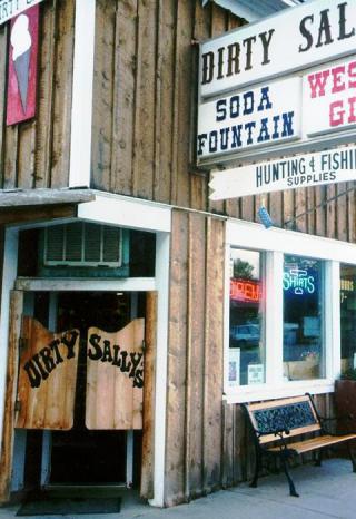
The area near present-day Ten Sleep, at the confluence of Tensleep Creek and the Nowood River in the southeastern Bighorn Basin, was one of the first places in the future county to be settled by white people. Its attractions included water and good forage for animals. Settlement began during the 1880s and 1890s, and several small stores or post offices were established as adjuncts to ranch headquarters at that time. Although more settlers arrived and started more businesses throughout the years, the town of Ten Sleep was not officially established until 1932.
In 1900, homesteader Charlie “Dad” Worland, living by the west bank of the Bighorn River, opened a small bar and general store for travelers. Within a few years, a second store opened, a post office appeared and a surveying crew came into the area. Settlers were attracted and by 1906, when the Burlington Railroad was being constructed south from Montana, a small town, "Worland's," had appeared on the spot.
The railroad passed close to the town, but on the east side of the river. Residents decided to move the town. They used horses to slide the buildings across the frozen river in January and February 1906. One structure, the hotel, says Pendergraft, spent several days stuck on the river’s bank and leaning to one side while business inside continued. Once the railroad arrived, even more settlers came to Worland.
As population grew in the southern Bighorn Basin, residents voted for Big Horn County to be divided. On Feb. 9, 1911, The Wyoming Legislature passed the law creating Washakie County, with Worland as the county seat. The new county became the only one in the state to be named for an Indian.
Irrigation and farming
Irrigation projects in Washakie County began to be constructed in 1902. Prior to this time, farmers were dependent on seasonal creeks. Now, water from the larger and more reliable Bighorn River was available. The first significant man-made waterway, the Hanover Canal, was constructed by crews working by hand and using horses to pull the equipment. The plan was to bring water from the Bighorn River to higher ground that was fertile but too dry for crops. The work was hard: Pendergraft estimates that two horses died for every mile of ditch dug.
As more irrigation and drainage projects were developed, farming grew in importance in the county economy. Beans, alfalfa, corn and sugar beets were the main crops. In 1912, an alfalfa mill opened in Worland. The Holly Sugar Company opened a beet-sugar factory there in 1917. Both these businesses helped assure farmers a market for their crops.
Sugar beets were one of the most important crops in Washakie County, especially after the factory opened. Caring for beets required large crews to thin the rows with hoes and by hand so that the beets would be properly spaced for efficient growth. Many workers were needed again to harvest beets in the fall. This work brought new groups of people to the county—initially Germans and Russians and later, Mexicans. Some newcomers stayed in the area and established their own farms or businesses.
Energy
In 1912, oil discoveries were made along the southwest margin of the Bighorn Basin, just outside the boundaries of Washakie County. Some Washakie residents were involved in the strikes, as owners or investors in exploration companies. In 1914, oil was found in Washakie County itself.
Initial discoveries were generally kept as secret as possible. A 1915 issue of the Worland Grit announced the discovery of "a monster gusher, although many details are lacking as the drillers . . . have maintained great secrecy as to what is going on." The amount of equipment shipped through Worland that was necessary for significant drilling on any new find often made keeping such secrets impossible.
World War I, meanwhile, briefly tripled oil prices. They were "as high," writes Pendergraft, "as $3.10 per barrel," and this motivated extensive exploration. The high prices brought even more disorder into the oil fields.
Before Congress passed the Mineral Leasing Act of 1920, each discovery prompted a scramble to claim and drill as much nearby land as possible. Claim jumping was chronic; incentives in the earlier law encouraged oilmen to produce as much oil as fast as they could, often draining the oil from neighboring tracts in the process. The new law brought order in the form of a leasing and royalty system on public lands, which continues today.
After the war, crop, wool and beef prices plunged, and Wyoming spun into an agricultural depression. Oil prices stayed relatively high, however, and the oil boom continued through much of the decade.
In Washakie County, the oil industry conflicted sometimes with established ranching and farming. One farmer’s beet field became the site of a road and an oil well before the beets were harvested; later he was compensated for the damage.
The Great Depression
This oil boom, however, died down as the Great Depression hit the nation after the stock market crash of 1929. Miners, drilling crews, factory workers and others were laid off. County and city employees who remained took pay cuts. Ranchers and farmers made tiny profits or none as prices of meat, corn, beets, wool and other agricultural products continued to fall.
Local governments stepped in to provide some jobs and other relief. They hired local men to oil and gravel existing roads, or build new roads and bridges.
Bootlegging was another source of income. It had been pursued since Prohibition began in 1919, but expanded with the disappearance of other jobs. "You should get busy," Pendergraft was advised by "an upright and well regarded individual," "and establish yourself a good bootlegging business and win the respect of this community." Repeal of the 18th amendment in 1933, however, shut down this profession.
Under President Franklin Roosevelt's policies, farmers were paid not to plant part of their land, and ranchers were paid for not raising livestock. The industrial work day was shortened to 8 hours, and minimum wage set at 32.5 cents per hour.
Fresh oil discoveries were made in Washakie county during the 1930s, but prosperity did not return until World War II.
World War II and after
With the start of war, prices began to rise, helping farmers and ranchers. Many men enlisted in the armed services, leaving vacant jobs. For the first time, women were hired at the Holly Sugar Company factory in Worland.
After the war, Washakie County moved with the rest of Wyoming in becoming more modernized. ("The various sections of the state are not isolated," boasted the 1966 edition of the Wyoming Guide. "Few of the settlements of 100 or more population are more than 10 miles away from an oiled highway.")
Agriculture, perhaps, changed more than any of the other Washakie County industries. In beet growing, for example, new seeds were developed to make thinning easier, machines replaced workers for thinning and harvesting, and chemical sprays replaced hand weeding.
New businesses started in Worland, including the Admiral Beverage Company that Newell and Mabel Sargent opened in 1945. Beginning as Pepsi-Cola Bottling Company with a staff of four people, the company eventually acquired plants in 5 states and hired more than 1,000 workers. It has provided many jobs in Worland over the years.
Modern times
The industries established between 1880 and World War I—ranching, farming and energy production—remain the foundation of Washakie County's economy.
Ranching is important but no longer central to the economy. Agriculture is almost completely mechanized and involves fewer family farms and more corporations than in previous years. Sugar beets are still an important crop, as are beans, corn and alfalfa. The energy industry has carried the county's economy on its boom and bust cycles since World War II.
Current state figures show that people who work for the federal, state and local governments in Washakie County make up by far the largest employment sector, followed by people who work in health care and social assistance, and third by people who work in retail sales.
Resources
Primary Sources
- "First Oil Well for Montana," The Worland Grit, Oct. 29, 1915.
- "Every Issue a Boost for a Better and Greater Worland," The Worland Grit, July 7, 1916.
- "This Morning the Jury Returned With a Verdict of Murder in First Degree," The Worland Grit, Nov. 11, 1909, 1. Article on the trial of the Spring Creek Raid attackers.
Secondary Sources
- "Admiral Beverage History." Admiral Beverage Corporation website. Accessed September 15, 2012 at www.admiralbeverage.com/history.html.
- Davis, John W. A Vast Amount of Trouble. Norman, Okla.: University of Oklahoma Press, 2005. The most comprehensive of the books about the Spring Creek Raid.
- ________________. Goodbye, Judge Lynch: The End of a Lawless Era in Wyoming's Big Horn Basin. Norman, Okla.: University of Oklahoma Press, 2005, 120-206.
- _________________. Sadie and Charlie: The Lives and Times of Sadie and Charlie Worland. Worland, Wyo.: Washakie Publishing Co, 1985, 13, 42-57.
- Donahue, James, ed., Wyoming Blue Book: Guide to the County Archives of Wyoming, Vol. V, Part I. Centennial Edition. Cheyenne, Wyo.: Wyoming State Archives, Department of Commerce, 1991, 803-807.
- Frison, George. The Colby Mammoth Site: Taphonomy and Archaeology of a Clovis Kill in Northern Wyoming. Albuquerque, N.M.: University of New Mexico Press, 1986, 1-25, 91-114.
- “Historic Crude Oil prices, 1861-Present.” Chart Bin, accessed Sept. 7, 2012 at http://chartsbin.com/view/oau.
- Hunt, Lester, ed. Wyoming: A Guide to its History, Highways and People. New York: Oxford University Press, 6th printing, 1966, 4
- Markley, Elinor and Beatrice Crofts. Walk Softly, This is God's Country: Sixty-Six Years on the Wind River Indian Reservation. Lander, Wyo.: Mortimore Publishing, 1997, 116-131.
- Larson, T.A. History of Wyoming. Lincoln, Neb.: University of Nebraska Press, 1965, 13, 163, 185.
- Pendergraft, Ray. Washakie: A Wyoming County History. Basin, Wyo.: Saddlebag Books, 1985, 1-22, 33-73, 132-193.
- Wasden, David. From Beaver to Oil: A Century in the Development of Wyoming's Big Horn Basin. Cheyenne, Wyo.: Pioneer Printing and Stationery Co, 1973, 7-44.
Illustrations
- The colorized post card of Big Horn Avenue in Worland in 1911 is from Wyoming Tales and Trails. Used with thanks.
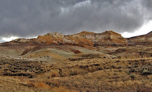
- The photo of badlands west of Ten Sleep, Wyo. is by Todd Hepler, from Panoramio. Used with thanks.
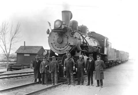
- The photo of the first train to come to Worland and its crew appears to have been taken during a reunion of the group in the 1920s. The train first arrived in Worland in 1906. Used with permission from and thanks to the Wyoming State Archives, Department of State Parks and Cultural Resources.
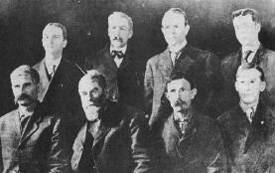
- The 1906 photo of Charles “Dad” Worland and the Worland town council, 1906, is from the Worland-Ten Sleep Visitor’s Council. Used with thanks.
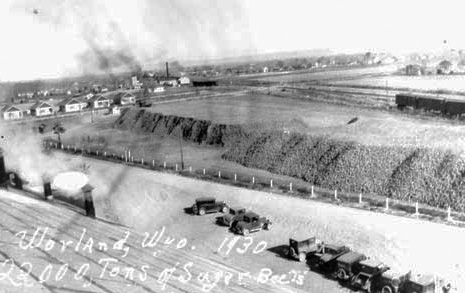
- The 1920s photo 2200 tons of sugar beets, near the railroad tracks in Worland and ready for shipping, is also from the Wyoming State Archives, Department of State Parks and Cultural Resources. Used with permission and thanks.
- The 1999 photo of Dirty Sally’s in downtown Ten Sleep is by Sheila Wilson, from Panoramio. Used with thanks.