Before Wyoming: American Indian Geography and Trails
“The Crow country is exactly in the right place,” Crow Chief Arapooish told U.S. Army officer Robert Campbell in the 1830s. “It has snowy mountains and sunny plains; all kinds of climates and good things for every season. When the summer heats scorch the prairies, you can draw up under the mountains, where the air is sweet and cool, the grass fresh, and the bright streams come tumbling out of the snow-banks.”
Arapooish clearly possessed a deep knowledge of geography and ecology in his part of the world, today’s northern Wyoming and southern Montana. His people followed seasonal abundance through the mountains and plains, making a living off the natural cycles of wildlife migrations. He described hunting elk, deer, antelope and bighorn sheep in summer at high elevations, where horses grew “fat and strong from the mountain pastures.”
In the fall, the Crow would hunt bison on the plains and trap beaver. With the coming of winter, they took shelter in woody bottoms, like those along the Wind River, that offered cottonwood bark and salt weed for grazing horses. This was the Crow strategy both for pursuing migratory game animals and for making the best use of forage, edible plants, and other resources on the landscape.
Such patterns of subsistence created the foundation of American Indian geography in this region through the mid-1800s. Indigenous knowledge of how to navigate and survive on the landscape was highly developed in all tribal cultures.
The historical record describes American Indians hunting migratory ungulates—that is, large, cloven-hoofed animals like elk, moose, deer, bison and pronghorn antelope—in all corners of Wyoming. Oregon Trail chronicler Francis Parkman encountered Oglala Lakota people hunting bison on the Laramie Plains in 1846 as did the Stansbury Expedition in 1850. In 1857, the Warren survey expedition found Dakotas surrounding a herd of bison in the northern Black Hills.
In 1859, the geologist Ferdinand Hayden found a pronghorn pit trap on a divide between the Cheyenne and North Platte Rivers in what’s now eastern Wyoming. Hayden’s guide, Michel “Mitch” Boyer, said Indian hunters had used the trap only eight years earlier, and that Arapahos had built it. In 1891, Theodore Roosevelt witnessed a party of Shoshone hunting elk just south of Yellowstone National Park at Two Ocean Pass, the headwaters of the Snake and the Yellowstone rivers.
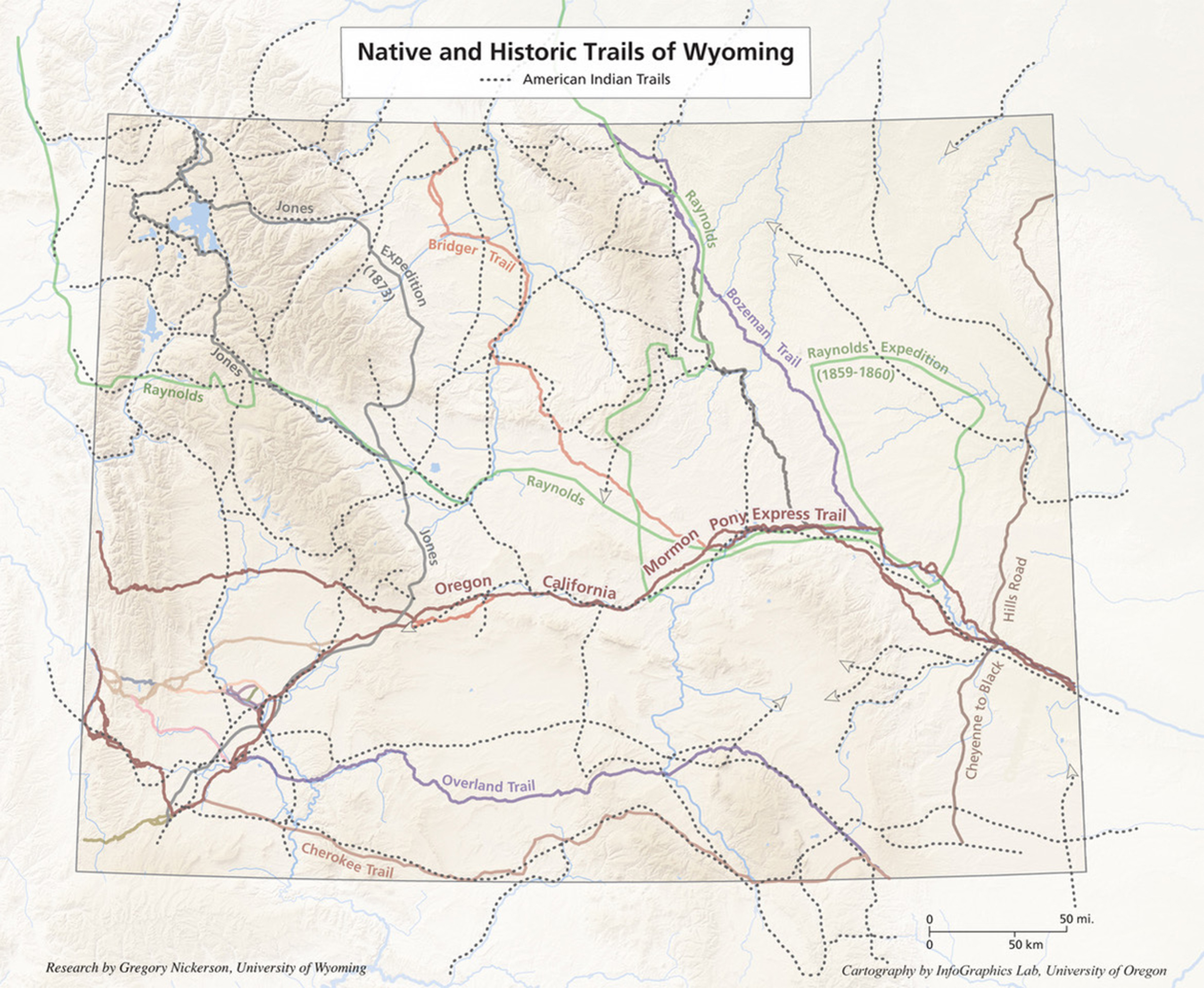
Tribes moved across an extensive network of trails to hunt migratory game and harvest plant resources. These same trails also served other purposes, such as trade, war, harvesting tepee poles or visiting extended family members. In many cases, the travel routes established by American Indians followed natural corridors of rivers or passes that traversed mountains and crossed between sagebrush basins.
Fur trappers, the military and settlers later incorporated these pragmatic American Indian routes into transportation routes like the Oregon Trail and the Bozeman Trail, the roads over Togwotee Pass in the Wind River Mountains or Sylvan Pass near the East Entrance to Yellowstone National Park, or the ring roads in Yellowstone. Even today, many of Wyoming’s highways roughly parallel routes established by pedestrian or horse-mounted hunters hundreds of years ago.
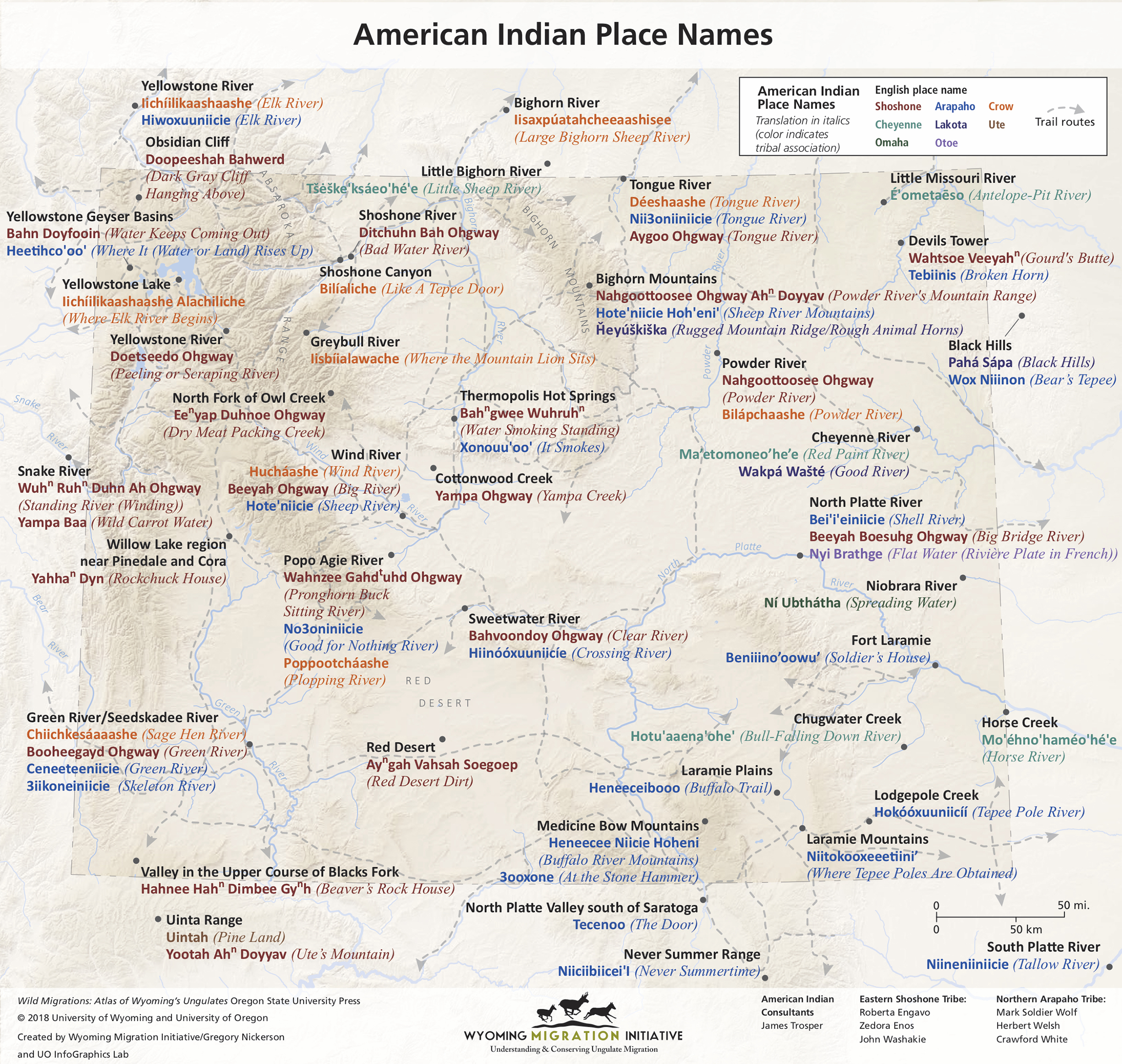
American Indian place names in what is now Wyoming describe a vivid world defined in part by the seasonal resources found at specific locations. Place names in Shoshone, Arapaho, Crow, Cheyenne, Lakota and other languages make clear that animal and plant foods like mountain sheep and yampa root shaped the indigenous concept of place. These names give us a glimpse of how people viewed the land as they moved across it through the seasons.
Eastern Shoshone routes
From 1825 to 1875, the Eastern Shoshone made seasonal trips through western Wyoming. Anthropologist Demitri Shimkin mapped these routes in the 1930s after consulting an 1875 report by Capt. William A. Jones and interviewing Shoshone elders. Shoshone people traveled west over the Wind River Range in spring, likely via South Pass, and arrived at Willow Lake north of present Pinedale, Wyo., in mid-June on the heels of migrating deer, pronghorn, and elk.
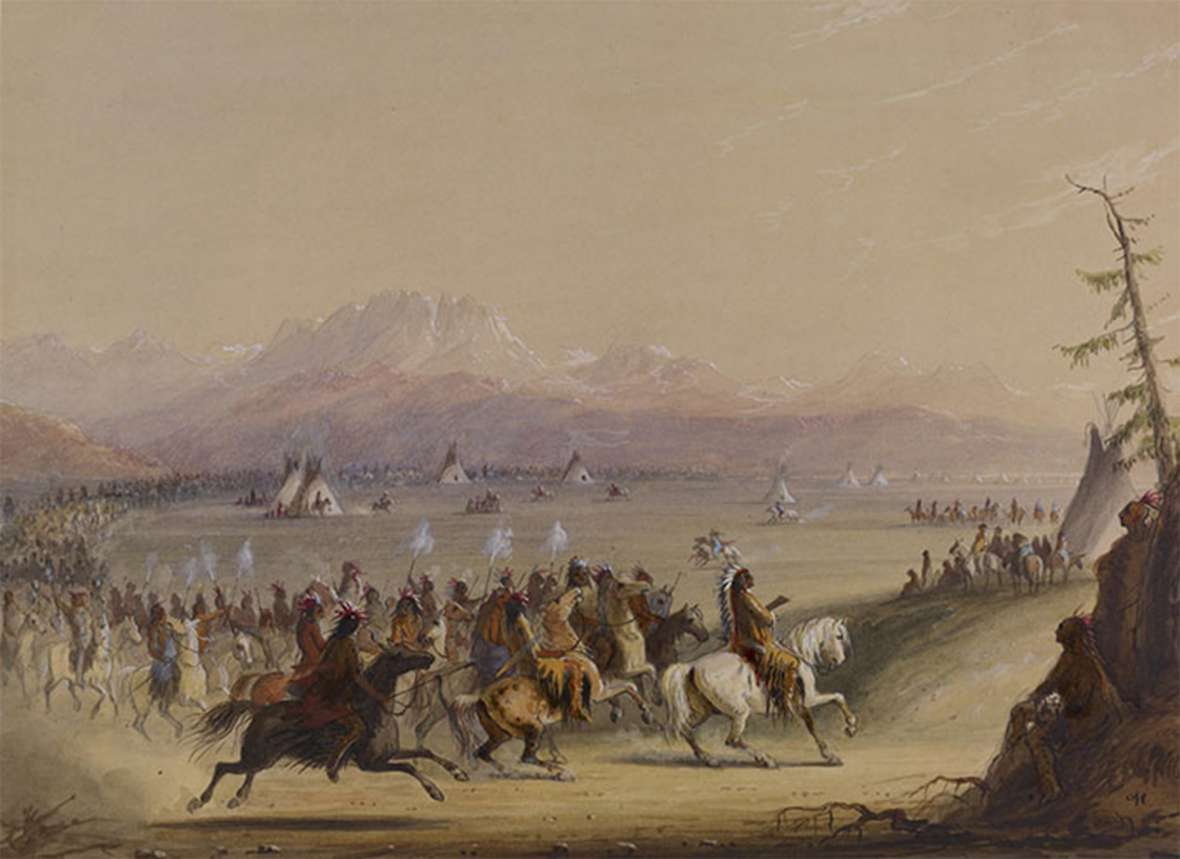
Here in the Green River Valley they traded at a major rendezvous that fur-trade artist Alfred Jacob Miller observed in the 1830s and later depicted in oils and watercolors. (This is the same general area where Astorian Robert Stuart stumbled upon the remains of a Shoshone ceremonial lodge in 1812 on his way to crossing South Pass.) Some Shoshones then moved south to harvest edible plants, trade at Fort Bridger and meet Shoshone-Bannock kin from farther west. In the fall, they returned to the Wind River, their base for buffalo hunting expeditions.
Shoshone routes informed travel of many fur trappers and travelers. For example, the Astorians traveled over Union Pass along trails familiar to the Shoshone. John Colter’s travels up the South Fork of the Shoshone River and in the Gros Ventre Range also paralleled existing Indian trails. In 1842, Lt. John C. Fremont of the U.S. Topographical Engineers entered the Green River Basin along a trail long used by the Shoshone to reach Willow Lake.
In 1873, the northwestern loop of Capt. William Jones’s expedition (see map) crossed Blondie Pass over the Owl Creeks, crossed near Sylvan Pass in the Absarokas, and back around through the Two Ocean country thanks to the navigation help of his Shoshone guide Togote, namesake of Togwotee Pass. Though Jones worried that he wouldn’t be able to enter Yellowstone from the east due to impassable mountains, and shouted for joy when he finally spotted Yellowstone Lake from near Sylvan Pass, Togote was on familiar hunting trails the entire trip.
In southwest Wyoming, Fort Bridger was built by traders taking cues from Shoshone trade gatherings that predated Jim Bridger or the Rocky Mountain fur trade. Where Interstate 80 crosses three ridges called “The Sisters” in Uinta County, the highway passes near valleys the Shoshone once used to harvest biscuitroot.
Northern Arapaho routes
Northern Arapaho hunting territory encompassed a huge area of the Great Plains and Rocky Mountains between the Yellowstone and Arkansas Rivers. Small bands followed spring migrations of bison, elk, deer and pronghorn into the Estes Park, North Park and Middle Park regions of today’s Colorado.
Before 1860, numerous military and survey expeditions in the Laramie Plains area and the upper North Platte River encountered Arapaho. On a pack trip in 1914, the Arapaho elder Sage described how in the mid-1800s mountain valleys like Estes Park were “game bags,” where confined topography allowed easy harvest of bison. In the fall, his band hunted lowland valleys like Lodgepole Creek in present southeastern Wyoming, and the South Platte River.
Sage described in detail the many Arapaho trails connecting Colorado’s mountain parks to the basins of southeast Wyoming, via routes along the North Platte River, the Laramie River, or the Cache La Poudre River. Today’s Highway 230 over the Medicine Bow Range parallels an old Indian trail between the Laramie Plains and North Park, Colorado.
Several Arapaho place names indicate resources they obtained in southeast Wyoming. The Arapaho name for the Laramie Plains, Heneeceibooo, means “Buffalo Trail.” Nearby, today’s Pole Mountain and Lodgepole Creek in the Medicine Bow National Forest correspond to the Arapaho place name Niitokooxeeetiini', which translates to “Where tepee poles are obtained.” The granite formations at Vedauwoo owe their name to the Arapaho’s Biito’owu’, which means “The Earth.”
Colorado’s gold rush and the Sand Creek Massacre caused the Northern Arapaho to focus their hunting in the north after 1865, spending time along the Bighorn Mountains; in the valleys of the Powder, Wind, and Sweetwater Rivers; and near Fort Robinson, Neb. In what is now northern Wyoming, the Arapaho used the name “Gooseberry Creek” for today’s Goose Creek that runs through Sheridan.
Trail markers
Many tribes marked their trails with stone cairns as they made seasonal journeys across basin and range. Some of these cairns line an old travel route near Kaycee that climbed the east slope of the Big Horn Range. Another route marked by these cairns and deep ruts helped the Raynolds survey expedition of 1859-1860 find their way from the Yellowstone River along the Bighorns to the North Platte River. The Raynolds route, in turn, informed the route of the Bozeman Trail, which Interstate 25 parallels today (see map).
Sheepeater routes
The Tukudika (Sheepeater) Shoshone gathered summer foods like camas root, pine nuts, trout and bighorn sheep in the high country around Yellowstone. Archaeological evidence suggests the Sheepeaters have one of the longest-duration occupations of what is now Wyoming of any American Indian group. The historical Tukudika used styles of tools like soapstone bowls that had been common in the area more than 1,000 years ago.
Many historic and prehistoric Tukudika trails follow today’s highways in Yellowstone Park, such as the road through Lamar Valley. Other trails, like the Washakie Trail over the crest of the Wind River Range, are today used as pack trails and hiking trails in the Shoshone National Forest and Bridger-Teton National Forest. Some of the Tukudika trails that anthropologist Demitri Shimkin recorded as connecting the Wind River, Shoshone, and Yellowstone River watersheds follow today’s elk migration corridors exactly.
Shoshone-Bannock routes
The Shoshone-Bannock hunted throughout Yellowstone, in the mountains surrounding the Snake River Valley and in the Wyoming Range of what’s now western Wyoming. In particular, they used the Bannock Trail across northern Yellowstone Park to access bison hunting grounds in the Bighorn Basin and along the Yellowstone River. This trail passes by important Yellowstone landmarks like Electric Peak, Mammoth Hot Springs, Obsidian Cliff, Lamar Valley and Sunlight Basin, a route that modern highways closely follow. Parts of the route were used by other tribes, including the Nez Perce, who were familiar with the route from bison hunting expeditions, and famously evaded the U.S. Army in Sunlight Basin during their desperate dash toward the Canadian border in 1877.
Crow routes
In north-central Wyoming, the name Tongue River comes from the Crow, who tell a story of a medicine man laying out 100 buffalo tongues on the bank of the namesake river as part of a ceremony. Likewise, the Popo Agie River near the Wind River Range comes from the Crow word Poppotchaashe. This word is an example of Crow onomatopoeia—a play on the sound of words—that translates to “plopping river.” The name of the Seedskeedee National Wildlife Refuge comes from the Crow’s Sage Hen River, Chiichkesáaaashe, today’s Green River.
The Crow historically hunted the Yellowstone River, the Greybull River, the mouth of Shoshone Canyon, Sunlight Basin, Powder River and areas around the Medicine Wheel in the Bighorn Mountains. Crow trails in the northern Bighorns closely follow today’s U.S. Highways 14 and 14A. The Crow trails around Medicine Mountain mirror the layout of elk migration corridors recently mapped by the Wyoming Game and Fish Department. The highway west of Cody, Wyo., between Cedar Mountain and Rattlesnake Mountain follows a route used by the Crow in the 1800s, as does the Greybull River Road near Meeteetse, and the highway into Sunlight Basin. Other Crow trails over the southern Bighorns are minor roads and two tracks across the National Forest.
Cheyenne routes
The Cheyenne hunted along the Laramie Mountains, the North Platte River to the east, and north around the Powder and Bighorn rivers. Today’s Interstate 80 across the Laramie Range follows trails used by the Cheyenne in the 1850s, according to journals of the U.S. Army’s 1849-1850 Stansbury Expedition. The Cheyenne often traveled through the Clear Creek Valley in what is now eastern Sheridan County, as well as the Rosebud Creek, Otter Creek and Tongue River country of Montana, a region connected to the Sheridan area today by long gravel roads.
Lakota Routes and Names
The Lakota Sioux expanded west across the Northern Plains in the early 1800s, pushing into traditional territory of the Crow, Cheyenne, Arapaho, and Shoshone. By the 1850s, the Lakota and subdivisions such as the Oglala dominated in the Yellowstone River Valley, the Powder River Basin, and even as far south as the Laramie Plains. The Lakota used many travois and hunting trails of predecessor tribes when traveling across the mountains and plains of eastern Wyoming.
Several Lakota place names remain in use today, such as Inyan Kara Creek near Sundance, Wyo. The name for the Black Hills is a direct translation from the Lakota Paha Sapa, a region at the center of the Tribe’s sacred origin story. Other Lakota names for the Bighorn Mountains and the Cheyenne River never came into common use. In 2014, the Oglala Sioux Nation requested that Devils Tower be renamed “Bear Lodge,” a translation of the Lakota Mato Tepee.The proposal was blocked by Wyoming’s congressional delegation until 2021.
Additional Tribal Place Names
Several tribes provided names still used today in Wyoming, though they were never historically associated with the region. The name Wyoming itself comes from tribes along the Susquehanna River in today’s Pennsylvania. There are several translations for Wyoming, according to writer Jim Brown: The Delaware word M’chewauminmeans "large plains" or “mountains and valleys alternating;” the Munsee xwé:wamənk translates to "at the big river flat;” in Algonquin Chwewamink is “a large prairie place.” U.S. Representative James M. Ashley of Ohio, a Pennsylvania native, first shifted the name 1,800 miles west when he proposed it for reorganizing the western part of Dakota Territory in 1865.
The Otoe on the lower Missouri River were one of the first tribes that Lewis and Clark encountered on their expedition upstream from St. Louis. Their name for one major Great Plains river with braided sandbars was Nyi Brathge, which means “flat water.” This was the source name for the territory and state of Nebraska. French trappers on the plains called this same waterway Rivière Platte, that is, “Flat River,”maintaining the Otoe meaning. In English, this name is rendered as Platte River, one of the most important natural features of Wyoming throughout history.
Another Great Plains people, the Omaha-Ponca lived along the lower half and below the mouth of a river they named NíUbthátha, which translates to “spreading water.” The Omaha-Ponca probably spent very little time on the headwaters of this high plains stream, hundreds of miles west near the Black Hills. Yet their name for the stream was preserved as the Niobrara River, which runs through Lusk, Wyo.
Shrinking tribal lands
Before the 1800s, there was no such thing as a hard border to tribal lands, as each nation held territory largely by force or alliance. Incursions into another tribe’s core territory for war or hunting were common, and an important economic activity. American Indian territories were highly permeable and continually evolving. Indigenous geographic knowledge often extended for hundreds of miles beyond a person’s lived experience, thanks to oral traditions and communication with distant trading partners. Individuals sometimes traveled great distances, like Sacagewea, who accompanied Lewis and Clark, or Washakie, who according to some Shoshone writers quarried red pipestone in today’s Minnesota.
The onset of treaties restricted American Indians from using traditional hunting grounds, plant gathering areas and trails, disrupting their ties to the land. Throughout the 1800s, the United States circumscribed traditional homelands, forcing tribes onto much smaller reservations. Travel restrictions on tribal members greatly reduced the lived experience of American Indians outside their direct environs. These actions, combined with pressure for youth not to speak indigenous languages, greatly disrupted the passage of traditional geographical knowledge and place names to subsequent generations.
Disputes over hunting rights
American Indians actively resisted this effort to undermine traditional geography. In repeated cases around the turn of the 1900s, American Indians traveling and hunting in traditional areas—some of which were backed up by treaties and tribal sovereignty—resulted in conflicts. Shoshone-Bannock hunting in western Wyoming led to the case of Ward v. Race Horse, which in 1896 went all the way to the U.S. Supreme Court. The high court ruled that Wyoming game laws were superior to the hunting rights guaranteed to the Shoshone and Bannock in their 1868 treaty. Similarly, the 1903 incident on Lightning Creek in eastern Wyoming pitted Lakota families from the Pine Ridge in South Dakota with traditional hunting knowledge of eastern Wyoming against a sheriff’s posse that feared the Indians were making an outbreak.
Other incidents were more peaceful. In 1906, Utes hungry from lack of rations left their reservation in Utah and took an old travel route north to the Sweetwater Valley in central Wyoming, eating small game and buying flour from ranchers along the way. The group continued to the North Platte River, where they camped and held dances. They bought supplies in Douglas, and were accused of killing livestock by the editor of a Casper newspaper. This was among the last of such free-ranging, horse-mounted journeys to find food on a landscape that had sustained American Indians for at least ten thousand years.
Yet even today, traditional geographic knowledge exists and brings up questions of sovereignty. The 2019 U.S. Supreme Court Case Herrera v. Wyoming pits a Crow man from Montana—who exerted his interpretation of Crow treaty rights to hunt on National Forest land in the Bighorn Mountains in Wyoming—against Wyoming game regulations. The incident in question is fully within a landscape that resembles what Arapooish described in the 1830s. The case, which the court decided in Herrera’s favor, has brought new attention to the geographical knowledge, traditional hunting practices and travel routes that predate modern-day political boundaries.
Present-day relevance of American Indian geography
Legal disputes aside, American Indian geographical knowledge has present-day relevance. Across the United States, tribes are making efforts to record place names and map traditional understandings of geography. The Internet has vastly accelerated the creation and publication of such maps. In many cases, these efforts serve the simple purpose of making American Indian people, culture and history more visible to mainstream audiences.
Cartographers, geographers and public officials are taking notice of this trend. For example, some tribes are working with state highway departments to use indigenous names for towns and rivers. Other tribes are requesting name changes through state geographic entities, or the U.S. Geological Survey’s Board of Geographic Names. The latter group has a policy that favors accepting Indian name proposals on tribal lands, allowing them to be recorded on the national Geographic Names Information System database. Such actions allow names to be available to future map makers and the public at large.
In Wyoming, indigenous geography continues to influence our highways, our culture and our way of life, by giving us a better understanding of the land, its natural processes and the people who call it home.
Editor’s Note: An earlier version of this essay first appeared in Wild Migrations: An Atlas of Wyoming’s Ungulates, which is a product of the University of Oregon/University of Wyoming’s Wyoming Migration Initiative. And special thanks to Wyoming Humanities, which supported development of this article.
Resources
- Anderson, Jeffrey D. 2003. One Hundred Years of Old Man Sage: An Arapaho Life. Lincoln: University of Nebraska Press.
- Beebe, Ruth. 1973. Reminiscing along the Sweetwater. Boulder, CO: Johnson Publishing Company.
- Chappell, Edith. 1981. “The Earliest Wyoming Trails.” In Powder River Country: The Papers of J. Elmer Brock, edited by Margaret Brock Hanson, 3-9. Cheyenne, WY: Frontier Printer.
- Clyman, James. 1960. James Clyman, Frontiersman: The Adventures of a Trapper and Covered-Wagon Emigrant as Told in His Own Reminiscences and Diaries. Edited by Charles Lewis Camp. Portland, OR: Champoeg Press.
- Condit, T. G. 1956. “The Hole in the Wall, Part II.” Annals of Wyoming 28(1): 27.
- Frison, G. C. 1981. “Linear Arrangements of Cairns in Wyoming and Montana.” In Megaliths to Medicine Wheels: Boulder Structures in Archaeology, Proceedings of the Eleventh Annual Chacmool Conference, edited by Michael Wilson, Kathie L. Road, and Kenneth J. Hardy, 133-147. Calgary: Archaeological Association of the University of Alberta.
- Frison, George C. 2014. Rancher Archaeologist: A Career in Two Different Worlds. Salt Lake City: University of Utah Press.
- Haines, A. 1962. “The Bannock Trails of Yellowstone National Park.” Archaeology in Montana 4(1): 1-8.
- Hebard, Grace Raymond, and E. A. Brininstool. 1922. The Bozeman Trail. Lincoln: University of Nebraska Press.
- Heidenreich, Adrian. "The 1812 Crow Indian Sun Dance Lodge: Description and Context." Proceedings of the 2012 Fur Trade Symposium, September 5-8, 2012. Pinedale, Wyo., 2013, 114-157.
- Irving, Washington. 1837. The Adventures of Captain Bonneville: Digested from His Journal. Philadelphia: J. B. Lippincott & Co.
- Jones, William Albert. 1875. Report upon the Reconnaissance of Northwestern Wyoming, Including Yellowstone National Park, Made in the Summer of 1873. Washington, DC: United States Army Corps of Engineers, Government Printing Office.
- Loendorf, L. L., and J. Brownell. 1980. “The Bad Pass Trail.” Archaeology in Montana 21(3): 11-83.
- Lowe, James A. 1999. The Bridger Trail: A Viable Route to the Gold Fields of Montana Territory in 1864. Norman, OK: Arthur H. Clark Co.
- McPhee, John. 1986. Rising from the Plains. New York: Farrar, Straus, and Giroux.
- Nabokov, Peter, and Lawrence L. Loendorf. 2004. Restoring a Presence: American Indians and Yellowstone National Park. Norman: University of Oklahoma Press.
- Parkman, Francis. 1900. The Oregon Trail: Sketches of Prairie and Rocky Mountain Life. 4th ed. Boston: Little, Brown & Co.
- Platt, Steve. 1992. “Trails and Aboriginal Land Use in the Northern Bighorn Mountains, Wyoming.” Master’s thesis, University of Montana.
- Raynolds, William Franklin. 1868. Report on the Exploration of the Yellowstone River. Washington, DC: Government Printing Office.
- Replogle, Wayne F. 1956. “Yellowstone’s Bannock Indian Trails.” Yellowstone Interpretive Series 6.
- Roosevelt, Theodore. 1906. “An Elk Hunt on Two Ocean Pass.” In The Wilderness Hunter. 3rd ed. New York: Charles Scribner’s Sons.
- Russell, C. 1945. “Trapper Trails to the Sisk-ke-dee.” Annals of Wyoming 17(2): 89-105.
- Shaul, David L. 2012. Eastern Shoshone Working Dictionary. Online.
- Spence, Mark David. 1999. Dispossessing the Wilderness: Indian Removal and the Making of the National Parks. New York: Oxford University Press.
- Stansbury, Howard, Spencer F. Baird, Charles Girard, Samuel S. Haldeman, John Torrey, and James Hall. 1852. Exploration and Survey of the Valley of the Great Salt Lake of Utah, Including a Reconnaissance of a New Route through the Rocky Mountains. Philadelphia: Lippincott, Grambo & Co.
- Stuart, Robert. 1953. On the Oregon Trail: Robert Stuart’s Journey of Discovery. Edited by Kenneth A. Spaulding. Norman, Okla.: University of Oklahoma Press.
- Thybony, Scott, Robert G. Rosenberg, and Elizabeth M. Rosenberg. 1985. The Medicine Bows: Wyoming’s Mountain Country. Caldwell, ID: Caxton Press.
- Tillman, Ralph, and Mary Tillman. 1999. The Glorious Quest of Chief Washakie. Filter Press, LLC.
- Toll, Oliver. 2003. Arapaho Names and Trails: A Report of a 1914 Pack Trip. Rocky Mountain Nature Association (Rocky Mountain Conservancy).
- Warren, G.K. 1875. Preliminary report of explorations in Nebraska and Dakota in the years 1855-'56-'57 by G.K. Warren.Washington: Government Printing Office, 1875. Pp.18-20.
- Wiles, Sara. 2012. Arapaho Journeys: Photographs and Stories from the Wind River Reservation. Norman: University of Oklahoma Press.
American Indian place names sources
- Cowell, Andrew, Alonzo Moss Sr., William C’Hair, Lloyd Dewey, and Mark Soldier Wolf. 2006. The Arapaho Project. Places and Placenames of the Arapaho: Culture on the Landscape. Online.
- Devils Tower National Monument. “Proposals to change the name.” National Park Service, U.S. Department of the Interior, accessed July 31, 2019 at https://www.nps.gov/deto/learn/historyculture/devils-tower-proposals-to-change-the-name.htm.
- Grinnell, G. B. 1906. “Cheyenne Stream Names.” American Anthropologist 8(1): 15-22.
- Guinn, Manfred, Beatrice T. Haukaas, Roberta Engavo, and Reba Teran. 2009. Shoshone Language Dictionary: Geographic Areas. Fort Washakie: Eastern Shoshone Cultural Center.
- Lakota Language Consortium. 2014. New Lakota Dictionary Online. Jan F. Ullrich, ed. Online.
- Little Bighorn College. 2012. Apsáalooke Place Names Database. Online.
- Petter, Rodolphe. 1915. English-Cheyenne Dictionary. Kettle Falls, WA: Valdo Petter.
- Shimkin, Demitri B. 1947. “Wind River Shoshone Ethnogeography.” Anthropological Records 5(4): 254-288.
Notes
- American Indian Consultants: James Trosper (Eastern Shoshone, Northern Arapaho), High Plains American Indian Research Institute, University of Wyoming. Eastern Shoshone Tribe: Roberta Engavo, Zedora Enos, John Washakie. Northern Arapaho Tribe: Mark Soldier Wolf, Herbert Welsh, Crawford White.
- On pronunciation, punctuation, and diacritical marks: typically, the double and triple vowels in indigenous languages signify long vowel sounds, apostrophes indicate glottal stops, and the pitch marks above letters indicate a high, low, or falling tone. The letter 3 in Arapaho place names signifies a “th” sound. The letter š in Cheyenne indicates an “sh” sound. The superscripts in Shoshone come from the Eastern Shoshone Cultural Center dictionary, which uses a phonetic alphabet for nasalized superscripts like “n” and other sounds. For more information, see these college and tribal websites: Arapaho Language Project at the University of Colorado, Survey of Shoshone Grammar by David Shaul at the Eastern Shoshone Tribe, Northern Cheyenne Dictionary available at Chief Dull Knife College, Crow Language Consortium at Little Bighorn College, Lakota Language Consortium.
For further reading and research
- Kauffman, Matthew J., Annie Proulx, James E. Meacham, Hall Sawyer, Alethea Y. Steingisser, William Rudd, and Emilene Ostlind. Wild Migrations: Atlas of Wyoming's Ungulates. Corvallis: Oregon State University Press, 2018.
Illustrations
- Both maps were prepared by the University of Oregon InfoGraphics Lab, together with the author, as part of the Wyoming Migration Initiative. Used with permission and thanks.
- The image of the Alfred Jacob Miller painting is from the collections of the Walters Art Museum in Baltimore available online. Used with thanks.
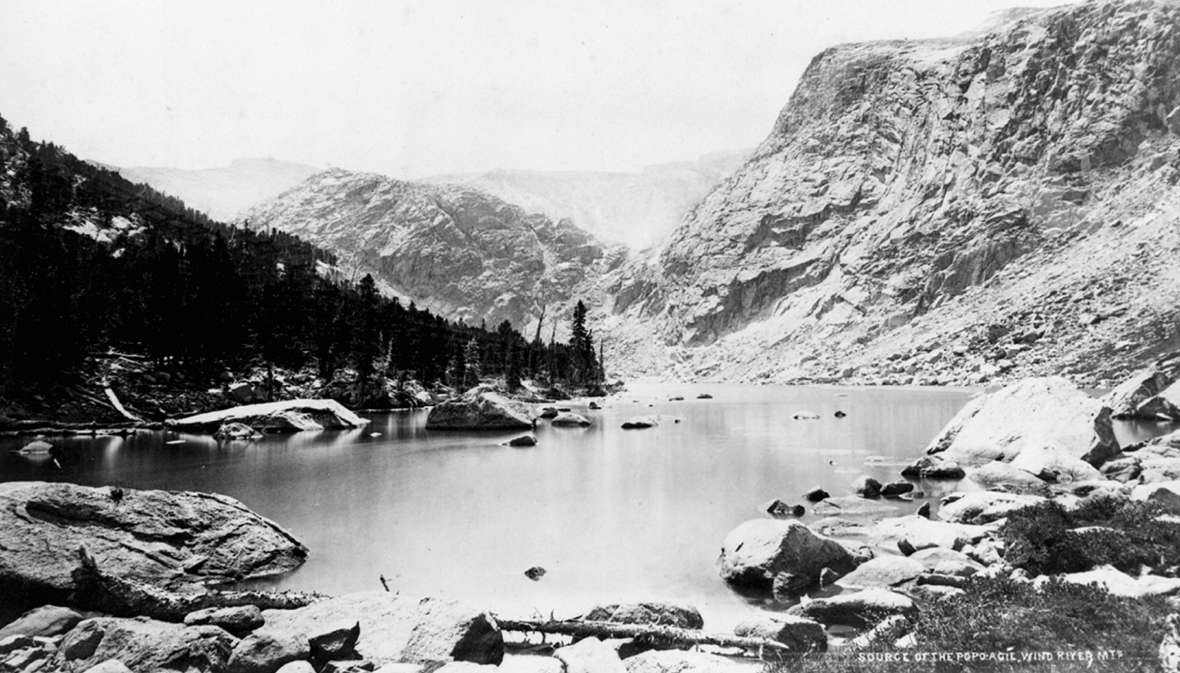
- The black and white William Henry Jackson photo of the source of the Popo Agie in the Wind River Mountains is from the Library of Congress. Used with thanks.